|
Can we forecast volcanic eruptions?
The answer to the question above depends to a certain degree on whom
you ask. Dan Miller of the Cascades Volcano Observatory, for one, is
bearish. "I don't think eruptions can be consistently predicted," he
told me. By contrast, volcanologist Bill Rose of Michigan
Technological University is bullish. "If we have enough money," he
said, "we can predict eruptions."
Why such widely divergent opinions? Can we or can't we?
The answer, perhaps not surprisingly, is complicated. In fact,
Miller and Rose are not as far apart on this issue as they might
sound. John Eichelberger, a volcanologist at the University of
Alaska Fairbanks, may have summed up the situation best when I asked
him if the field was well on its way to becoming an exact science or
was still in its infancy. He chuckled and said, "Well, when it
works, it's well on its way. When we have a spectacular failure,
it's in its infancy."
 When it works, when it fails

Both scenarios have occurred in recent years. Mt. Pinatubo in the
Philippines is one of eruption forecasting's great success stories.
When it awoke in the spring of 1991, volcanologists rushed in,
installed monitoring equipment, and correctly identified the nature
of the unrest. They rapidly completed a hazard assessment, based in
part on looking at evidence from past eruptions there. And they
provided good advice to public officials and the Philippine and U.S.
militaries. Just days before the mountain exploded on June 15, the
Filipino government successfully evacuated more than 60,000 people
from towns and villages (and the U.S. Clark Air Base) that were
later partly or wholly destroyed.
Tungurahua volcano in Ecuador, on the other hand, might fall in the
"spectacular failure" category of eruption forecasting. (Like
meteorologists, most volcanologists tellingly prefer the less
precise term "forecasting" to "predicting.") When Tungurahua woke up
in 1999, volcanologists from the USGS's Volcano Disaster Assistance
Program (VDAP) quickly helped their Ecuadoran colleagues set up
monitoring equipment to evaluate the hazards and track the volcano's
restlessness. When a magmatic eruption began there, the team smelled
trouble: Three well-documented eruptions within the past 300 years
that had begun just that way had resulted in explosive eruptions
that devastated the volcano's flanks and killed large numbers of
people. Based on the 1999 team's urgent recommendation, the
Ecuadoran authorities evacuated more than 15,000 people living
beneath the volcano.
Five years later, Tungurahua, while gurgling on a daily basis, has
yet to produce any major explosive eruptions. "It was an economic
and political disaster, and a worse one is in the making, because
those 15,000 people returned to their villages and have
categorically refused to leave again," says Miller, who directs VDAP
and led the 1999 team. Miller fears the mountain could still produce
damaging eruptions.
Why the disparity in results between Pinatubo and Tungurahua? The
reason is that when a volcano shows signs of disquiet, even one that
is thoroughly known and instrumented, volcanologists can still never
be certain when it will erupt, in what way, and to what
degree—or even if it will erupt at all.
Reason for hope
While that may not sound reassuring, the volcanological community
has actually made great strides in eruption forecasting in recent
years. Arguably the most significant strides have come in the
development of new tools for detecting changes in a volcano's
seismicity, ground deformation, and gases—the Big Three to
watch at an active volcano.
Seismic networks have improved enormously. Broadband seismic sensors
coupled with improved telemetry and computer systems now enable
volcanologists, like never before, to receive, analyze, and display
information about the earthquakes that typically precede eruptions.
When it comes to gauging the slight swellings of ground surface that
can signal an impending eruption, volcanologists today use
satellite-based Synthetic Aperture Radar systems that can detect
even the minutest elevation changes over an entire volcano, as well
as ground-based GPS units that can communicate deformation data to
volcano observatories in near real time.

So can we forecast eruptions? The best answer, for now, seems to be
“sometimes.”

As for monitoring gases, volcanologists two decades ago mostly
measured releases of sulfur dioxide, which can give an indication of
whether potentially explosive magma is approaching the surface. But
now they can monitor a suite of gases, primarily sulfur dioxide,
carbon dioxide, and hydrogen sulfide. Flying through a plume of gas
rising from a volcano, volcanologists can very accurately calculate
the flux of these three gases in terms of tons per day.
Researchers are even starting to reach within volcanoes themselves
in hopes of getting a better idea of their plumbing. Eichelberger is
part of an international team that in July 2004 managed to drill
into the main magma conduit that feeds Unzen, a dangerously active
volcano in Japan. (An eruption there in 1792 killed more than 15,000
people—see
Deadly Volcanoes.)
The conduit's now-solidified contents, samples of which the team has
collected, hold valuable clues to the magma's composition,
temperature, and pressure as it rose to the surface during Unzen's
last eruption, which lasted for four years in the early 1990s.
Hurdles
Despite these advances, many obstacles remain to successful
forecasting. For starters, it takes a long time to gain a good
understanding of even a single volcano's behavior. The more former
eruptions to study the better, but if a volcano only erupts on
average every several hundred years, that understanding can be
elusive.
For some major eruptions, volcanologists have had virtually nothing
to work from. The 1912 explosion of Novarupta volcano in Alaska was
the most dramatic volcanic event of the 20th century, packing 10
times the force of Mt. St. Helens's May 18, 1980 eruption. But the
magnitude of the cataclysm came as a complete surprise. "I doubt
even today if we would guess the scale of it, because nothing like
that had happened there for millions of years," says Eichelberger,
who doubles as Coordinating Scientist for the Alaska Volcano
Observatory. "You don't guess complete changes in behavior like
that."
Moreover, every volcano has a unique plumbing system, and each has
its own supply rate of magma from sources deep underground. That
means generalizing from one to the next can be tricky. "In other
words, what we've learned about Mt. St. Helens does not tell us much
about Mt. Shasta or Mt. Hood," says Miller, who is based in the
Cascade Mountains of the Pacific Northwest. Even for the best known
and best instrumented volcanoes in the world, volcanologists can
never be certain how they will behave when they come alive. Despite
numerous well-studied eruptions at Mt. St. Helens since the 1980
catastrophe, for instance, experts were unable to say during its
awakening in 2004 whether its eruptions would be effusive or
explosive—that is, a burp or a blast.
Other obstacles to forecasting are financial. "The problem is, there
are 900 potentially active volcanoes in the world, and only about a
tenth of them are instrumented enough to provide forecast
capability," Bill Rose says. "We have the technology to do it, but
the cost is too high to instrument the whole world." Many
threatening volcanoes in Central and South America, Africa, and the
southwest Pacific have little or no scientific scrutiny. Cerro
Quemado in Guatemala, for example, has tens of thousands of people
living around it, yet Miller says he's not aware of any monitoring
on that peak, not even a single seismometer. Even the USGS has
limited funding for researchers eager to plumb scientific questions
about possibly dangerous volcanoes in the U.S. "Basically we're
doing the best that we can with the budget we have, using the tools
that give us the biggest bang for the buck," Miller says.
So can we forecast eruptions? The best answer, for now, seems to be
"sometimes."


|

|
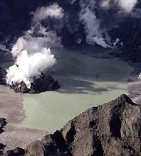
Blowing hot and cold: active volcanoes like Mt.
Pinatubo, whose simmering crater is shown here just over
a year after the major eruption of June 15, 1991, keep
experts ever on their toes for possible unrest.

|
|
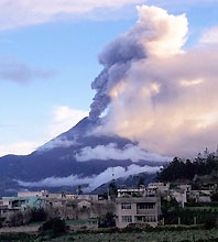
|
Ecuador's Tungurahua stands ominously close to
settlements like Pelileo, pictured here in early 2000.
When the mountain came alive in 1999-2000, officials
evacuated the nearby town of Banos for three months.
|
|
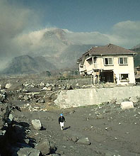
|
Mudflows from Unzen volcano took out most of the ground
floor of this house in Shimabara, Japan. In this photo
from March 1992, Unzen continues to erupt in the
background.
|
|
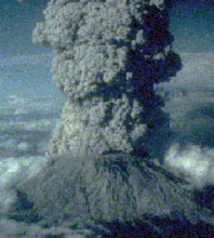
|
After its monster cataclysm of May 18, 1980, Mt. St.
Helens continued to erupt periodically for several
months. Here, an eruption plume from July 22 of that
year dwarfs both St. Helens and Mt. Rainier in the
distance.
|
|
|