
|
(back to part 2)
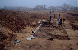 These two 5 x 5 meter squares were excavated together, starting 20 meters west
of D14, or 50 meters west of the bakeries area (fig. 1). Thomas Kittredge and
Mohsen Kamel supervised these squares. Our attention was directed here by
several patches of compact limestone rubble exposed by the modern sand diggers
from the riding stables since our last season. The largest patch, about 12
meters long, is located more than 60 meters from the SE corner of the mudbrick
wall to which the bakeries are attached in our 1991 area A7. D8-9 was laid out
to give a profile across this patch of rocky material with the idea that it may
mark an end to a larger mudbrick complex of which the buildings found in and
near A7 were a part.
These two 5 x 5 meter squares were excavated together, starting 20 meters west
of D14, or 50 meters west of the bakeries area (fig. 1). Thomas Kittredge and
Mohsen Kamel supervised these squares. Our attention was directed here by
several patches of compact limestone rubble exposed by the modern sand diggers
from the riding stables since our last season. The largest patch, about 12
meters long, is located more than 60 meters from the SE corner of the mudbrick
wall to which the bakeries are attached in our 1991 area A7. D8-9 was laid out
to give a profile across this patch of rocky material with the idea that it may
mark an end to a larger mudbrick complex of which the buildings found in and
near A7 were a part.
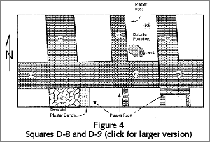
 Underneath a layer of fallen mudbrick and stone—the collapse and
deterioration of the walls such as we have found in almost every square—the
east-west line of the large mudbrick wall continues (890, 893), here more as a
single construction than in D17 and D14 (fig. 5). The wall was robbed
out in these squares almost down to the lowest course of bricks in some places.
The same wall, 1.5 meters thick, appears to turn a corner and to run north
(892). If this can be taken as the southwest corner of an enclosure, whose
southeast corner is that to which the bakeries attach, the layout is just under
65 meters wide. However, a less substantial wall (868) continues the east-west
line farther west, running beyond the west side of square D8. A wall built of
broken stone (894) runs from the "corner" farther south, beyond the south balk
of square D8. It is the collapse of this wall that produced the patch of
limestone rubble. The south face of the east-west wall (893), and the east face
of the stone wall (894), have a thick coat of tafla plaster. There is a tafla-
plastered bench (897) along the base of the stone wall. Smaller walls (866),
some a single brick thick, run south from the main east-west wall. These
defined small enclosures that contained caches of complete, or nearly complete,
ceramic vessels, mostly crude red ware jars and bread molds.
Underneath a layer of fallen mudbrick and stone—the collapse and
deterioration of the walls such as we have found in almost every square—the
east-west line of the large mudbrick wall continues (890, 893), here more as a
single construction than in D17 and D14 (fig. 5). The wall was robbed
out in these squares almost down to the lowest course of bricks in some places.
The same wall, 1.5 meters thick, appears to turn a corner and to run north
(892). If this can be taken as the southwest corner of an enclosure, whose
southeast corner is that to which the bakeries attach, the layout is just under
65 meters wide. However, a less substantial wall (868) continues the east-west
line farther west, running beyond the west side of square D8. A wall built of
broken stone (894) runs from the "corner" farther south, beyond the south balk
of square D8. It is the collapse of this wall that produced the patch of
limestone rubble. The south face of the east-west wall (893), and the east face
of the stone wall (894), have a thick coat of tafla plaster. There is a tafla-
plastered bench (897) along the base of the stone wall. Smaller walls (866),
some a single brick thick, run south from the main east-west wall. These
defined small enclosures that contained caches of complete, or nearly complete,
ceramic vessels, mostly crude red ware jars and bread molds.
 Along the north side of the main east-west wall (893), other thick mudbrick
walls (713, 750) run north and define a series of chambers. The same kind of
chambers, perhaps a modular series attached to the north side of the whole
east-west wall line, may be indicated by the walls in D17 and D14 (fig. 1). It
is possible that these are workshops. We recall the evidence of copper slag
found in D17 (fig. 2), inside what might be a chamber like those in D8-9. The
central chamber of those on the north side of the east-west wall in D8-9 had a
series of dolerite hammer stones scattered about on a dark ashy layer that
covered the floor (891). Underneath the ashy deposit, the floor was speckled
with yellow and red pigment. Larger pieces of red pigment, possibly hematite,
were found at the north end of this chamber. The hammer stones might have been
used for grinding pigment for paint.
Along the north side of the main east-west wall (893), other thick mudbrick
walls (713, 750) run north and define a series of chambers. The same kind of
chambers, perhaps a modular series attached to the north side of the whole
east-west wall line, may be indicated by the walls in D17 and D14 (fig. 1). It
is possible that these are workshops. We recall the evidence of copper slag
found in D17 (fig. 2), inside what might be a chamber like those in D8-9. The
central chamber of those on the north side of the east-west wall in D8-9 had a
series of dolerite hammer stones scattered about on a dark ashy layer that
covered the floor (891). Underneath the ashy deposit, the floor was speckled
with yellow and red pigment. Larger pieces of red pigment, possibly hematite,
were found at the north end of this chamber. The hammer stones might have been
used for grinding pigment for paint.
In summary, while the large mudbrick wall that was our original interest may
turn a corner in D8, other walls show that the whole complex continues father
west and south. The south side of the east-west wall line (890, 893) may have
been organized for pottery storage. The walls (713, 750, 892) running north
from the north side of the east-west wall line may suggest a series of
chambers, which may in fact continue all the way east to D14 and D17. There is
evidence that two of these chambers were for craft work and metallurgy.
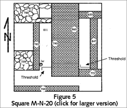
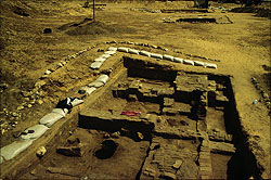
Square M-N20, supervised by Carl Andrews, is not located on a round 5 meter
grid position (fig. 1). It actually straddles squares N20 and M20. We had to
shift its location due to the enormous amounts of modern material dumped here.
Such modern dumped material generally increases to the north and west in Area
A. At M-N20, the front loader was required to remove material dumped in the
1980's and 1990's for a height of nearly 4 meters. M-N20, therefore, was at the
bottom of a trench cut through this modern debris.
 Along the west side of the square there are two large pedestals (759, 760),
built of broken stone and mud mortar. East of these pedestals, mudbrick walls
(790, 792) enclosed a long narrow gallery, or magazine, the interior walls of
which were lightly plastered with tafla (desert clay). The magazine opened on
the south to a step down along a threshold with thicker tafla plastering and a
lower surface paved with gypsum. Just inside this threshold, against the west
wall, we found a red ware jar standing upright. There was a hearth embedded in
the floor (811) at the back center of the magazine. A crude ceramic cooking
tray was embedded in the blackened floor and ash.
Along the west side of the square there are two large pedestals (759, 760),
built of broken stone and mud mortar. East of these pedestals, mudbrick walls
(790, 792) enclosed a long narrow gallery, or magazine, the interior walls of
which were lightly plastered with tafla (desert clay). The magazine opened on
the south to a step down along a threshold with thicker tafla plastering and a
lower surface paved with gypsum. Just inside this threshold, against the west
wall, we found a red ware jar standing upright. There was a hearth embedded in
the floor (811) at the back center of the magazine. A crude ceramic cooking
tray was embedded in the blackened floor and ash.
 The east and north part of the square remained problematic at the end of the
season. Most of this area is covered by mudbrick at different levels. The whole actually
has the appearance of a continuous mudbrick terrace (847,850,869). We possibly
have walls (847, 869) defining another, narrower magazine, although this is not
certain, principally because there is a thin wall (773) across what would be
at the south end, and because the "floor" of the "magazine" is covered with a
lower layer of bricks. Below wall 773, across the "threshold," we found
another plastered step somewhat on-line with the step across the entrance of
the western magazine.
The east and north part of the square remained problematic at the end of the
season. Most of this area is covered by mudbrick at different levels. The whole actually
has the appearance of a continuous mudbrick terrace (847,850,869). We possibly
have walls (847, 869) defining another, narrower magazine, although this is not
certain, principally because there is a thin wall (773) across what would be
at the south end, and because the "floor" of the "magazine" is covered with a
lower layer of bricks. Below wall 773, across the "threshold," we found
another plastered step somewhat on-line with the step across the entrance of
the western magazine.
The central mass of brick (790 + 869) is about 1.50 to 1.60 meters thick, and
it may line up with the 1.50-meter thick wall running north from the corner
where the bakeries are attached (fig. 1). However, the line is interrupted along
the south side of square M-N20 by a corridor defined by an east-west mudbrick
wall (766) that is partially excavated, but partially embedded in the south
balk. The bottom of the corridor, shown blank in fig. 5 like the eastern
"magazine," actually has a mudbrick pavement at the east and west ends. In
this square we may be seeing different phases—a later building superimposed
on an earlier one.
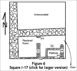
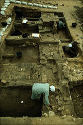
This was the last square that we opened this season. John Nolan refused to
realize that when archaeologists move into positions of directing (John acted
as Assistant Director this season), they administrate more than excavate. So he
insisted on taking a look into I17. Recall that we had laid out I17 (fig. 1)
in the hopes of finding part of the core house or institution to which the
industries of the outer enclosure were attached. We were, therefore, surprised
to find the closest thing we have seen in our excavations since 1988 to a small
modular house like those in workmen's towns at other sites from later periods.
 We began to excavate the ancient deposits within I17 as late as March 6, and
so we have only partially excavated the first phase of these deposits. I17 is
located 15 meters north and 15 meters west of the areas where we found evidence
of fish-processing in 1995 in squares F19 and G20 (fig. 1). Underneath the
architectural decay and tumble, the plan of a small structure quickly came to
light. It is defined by stone rubble walls (825, 826, 839), like the bakeries
that we found in 1991. However, thin mudbrick walls (871, 848) project from
the south wall of the structure. Together the walls form the closest thing we
have found to a simple house plan. To the east, the first mudbrick partition
wall (848) may form an entrance at the northeast corner of the structure.
Inside, the second mudbrick partition wall (871, 872) gives the sense of an
extremely simplified divided court house plan, leaving two main rooms. In the
first room to the east, mud and debris had been encased with mud bricks (925)
to form a platform (870). The inner room contained a good deal of ash (876),
perhaps from a simple hearth. It appears as though a similar structure may lie
in the unexcavated north half of I17.
We began to excavate the ancient deposits within I17 as late as March 6, and
so we have only partially excavated the first phase of these deposits. I17 is
located 15 meters north and 15 meters west of the areas where we found evidence
of fish-processing in 1995 in squares F19 and G20 (fig. 1). Underneath the
architectural decay and tumble, the plan of a small structure quickly came to
light. It is defined by stone rubble walls (825, 826, 839), like the bakeries
that we found in 1991. However, thin mudbrick walls (871, 848) project from
the south wall of the structure. Together the walls form the closest thing we
have found to a simple house plan. To the east, the first mudbrick partition
wall (848) may form an entrance at the northeast corner of the structure.
Inside, the second mudbrick partition wall (871, 872) gives the sense of an
extremely simplified divided court house plan, leaving two main rooms. In the
first room to the east, mud and debris had been encased with mud bricks (925)
to form a platform (870). The inner room contained a good deal of ash (876),
perhaps from a simple hearth. It appears as though a similar structure may lie
in the unexcavated north half of I17.
The similarity of this structure to a workman's house was a surprise to us.
On the other hand, it may not be a house at all, but another workshop. Many
flint tools or parts of tools were found in the deposits in this structure. A
high priority for next season is to expand our excavations in and around I17,
and to link up with the area where we found the low benches and evidence of
fish processing in 1995.
(continue: Square D19 and the Older Phase)
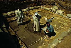
Photos: Carl Andrews and Mark Lehner
Pyramids Home | Pyramids | Excavation
Contents | Mail
|