
|
(back to part 1)
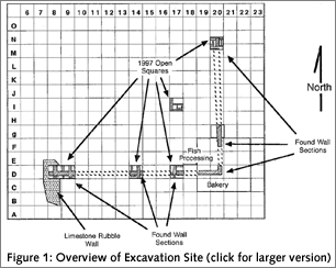
Organization of Excavation Squares
In 1991 we opened a 15 x 20 meter area around the bakeries and the modern back
hoe trench. We called this general area A7. In 1995 we expanded the
excavations by a system of 5 x 5 meter excavation squares, illustrated in fig.
1. The files of squares running north-south have letter designations, while the
rows running east-west have numbers. Each square is identified by letter and
number. In 1995 we found the 'fish-processing' area of benches and channels in
squares F19 and G20.
One of our objectives this season was to trace the large mudbrick wall, which
makes a corner beside the bakeries, to the north and to the west. We also
wanted to move to the northwest, inside the enclosure, to investigate the
possibility of a core house or institution to which our food production
facilities might be linked. On February 2 we surveyed and staked the following
squares: D17, D14, D9, D8, I17, and M-N20 (fig. 1).
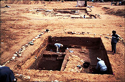
Excavation began within these squares on February 4. Even with the removal of
the most recently dumped modern material by the front loader, there was nearly
a meter or more of additional modern material to excavate in each square before
finding the ancient deposits, except in squares D8 and D9 where very little
modern material had yet been dumped.
Next we had to confront the 'mysteries of the mud mass' in each square, as
John Nolan outlined in his dispatches. Somewhere within this shapeless mass,
left from the disintegration of the mud brick and stone rubble walls, lay the
remains of the walls themselves, and it is all too easy to cut away, with
careless pick and trowel, the very walls we are looking for. As walls, rooms,
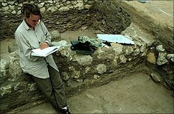
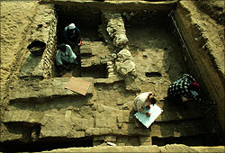
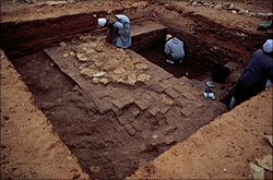
and floors were exposed, the square supervisors spent much time mapping each
feature, including each and every brick found in place within the walls. Here
we can only show our most preliminary, schematic plans (figs. 2-6). Our
detailed maps will be published when they have been drafted from the field
drawings.
 We give every feature in our excavations—layers, floors, post holes
hearths, walls—its own "feature number." I use these numbers in the
schematic square maps to describe what we found. Even if we believe that we are
seeing parts of the same wall in different squares, that wall has a different
number in each square. So, for example, we believe we have found a
continuation of the main wall to which the bakeries are attached, but, since we
cannot be sure it is the same construction, or constructed at the same time,
until we open all intervening squares, it has a different number in each
square.
We give every feature in our excavations—layers, floors, post holes
hearths, walls—its own "feature number." I use these numbers in the
schematic square maps to describe what we found. Even if we believe that we are
seeing parts of the same wall in different squares, that wall has a different
number in each square. So, for example, we believe we have found a
continuation of the main wall to which the bakeries are attached, but, since we
cannot be sure it is the same construction, or constructed at the same time,
until we open all intervening squares, it has a different number in each
square.
Each excavation square is like a window that allows us to look down onto the
ruins of an archaeological tableau that housed structures of everyday life
during the time of the Giza Pyramids. Or, in another sense, each square is a
piece of the puzzle. Looked at individually, and then altogether, we try to
understand and extrapolate the overall structure to which the pieces belong.
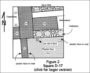
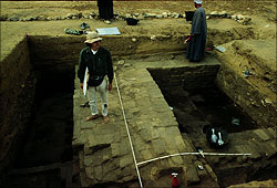
Justine Way supervised this excavation square, the first to the west of our
1991 area A7, located 10 meters west of the bakeries (fig. 1). We did find the
westward continuation of the large mudbrick wall (785) to which the bakeries
attach. The south side of the wall in this square was built with broken
limestone and large pieces of alabaster set in mud mortar. The north side had
been severely robbed of mud bricks in ancient times. Near the east side of the
square, the brick robbers had almost removed the wall (fig. 2). After the bricks
were robbed, a huge amount of pottery, animal bone, and other material was
dumped over the remains of this wall. A limestone wall and mud mortar wall
(741) that we found along the north side of D17, was built upon this dumped
material. Both the later stone wall (741) and the large east-west mudbrick wall
(785) attach to another large mudbrick wall (742) that runs north-south. From
the south end of this, a thinner mudbrick wall (831) continues south, defining
an enclosed area that we partially excavated in the southeast part of D17.
This was a room with a tafla-paved floor (854), in which a jar had been set. A
hearth, or other fire-installation, in the northeast corner of our excavation
of this room (878) left a bright orange deposit on the floor.
 In the northwest corner of D17, a narrow space was formed between the
north-south wall (742), the wall that continued to the west (807), and the west
side of D17. In the south end of the narrow space, we found another
fire-installation (881) or hearth that had scorched the walls and nearby
deposits to a bright orange. The deposit (877) in this space contained a few
fragments of bread molds and nearly complete bread molds. The heavy fraction
from our flotation of this material yielded many fragments of copper slag,
evidence of metallurgy within this chamber.
In the northwest corner of D17, a narrow space was formed between the
north-south wall (742), the wall that continued to the west (807), and the west
side of D17. In the south end of the narrow space, we found another
fire-installation (881) or hearth that had scorched the walls and nearby
deposits to a bright orange. The deposit (877) in this space contained a few
fragments of bread molds and nearly complete bread molds. The heavy fraction
from our flotation of this material yielded many fragments of copper slag,
evidence of metallurgy within this chamber.
 To summarize, the robbing of the mudbrick wall (785), the dumping over it, and
rebuilding with a stone wall (741) gives evidence that the history of the
latest occupation phase—including the bakeries and the fish-processing area—is more complex than we had realized. We have evidence of copper working in
a chamber partly excavated in the northwest corner of the square.
To summarize, the robbing of the mudbrick wall (785), the dumping over it, and
rebuilding with a stone wall (741) gives evidence that the history of the
latest occupation phase—including the bakeries and the fish-processing area—is more complex than we had realized. We have evidence of copper working in
a chamber partly excavated in the northwest corner of the square.
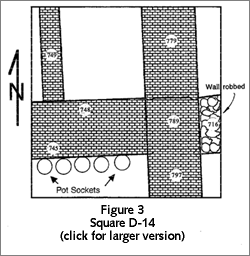
D14, supervised by Jason Ur, was located 15 meters west of D17, about 25 to 30
meters west of the bakeries area (fig. 1). Here, again, we found the line of
the large mudbrick wall, about 1.5 m thick, running east-west (716, 745=748).
Once again, as in D17, bricks had been robbed from this wall in antiquity.
Another similarity with D17 is that the line of the east-west wall is
continuous to the west, but it appears to be built in segments (716, and 745-
748) between equally large north-south walls. One well-preserved part of such
a north-south wall (779) was found along the east side of D14. Where the
east-west wall line (716) came in to meet the north-south wall (779-789-797) in
the narrow space along the east side of the square, the east-west wall (716)
had been partially robbed, and it did not appear as substantial as the
north-south wall.
 The rooms defined by the walls in these squares all had black ashy deposits on
the floor. Part of a room was found in the southwest corner of the square. A
series of shallow depressions in the floor, paved with sand and tafla, were
probably receptacles for pots or large jars that
had been removed. These lay
under a layer of black ashy material in which we found a fair amount of very
fragile animal and fish bone. A complete flint knife was also found in this
ashy deposit.
The rooms defined by the walls in these squares all had black ashy deposits on
the floor. Part of a room was found in the southwest corner of the square. A
series of shallow depressions in the floor, paved with sand and tafla, were
probably receptacles for pots or large jars that
had been removed. These lay
under a layer of black ashy material in which we found a fair amount of very
fragile animal and fish bone. A complete flint knife was also found in this
ashy deposit.
 In summary, the evidence of D14 indicates the importance and temporal priority
of the north-south running walls, which is possibly suggested in D17 as well.
There is evidence for butchering and other meat processing, possibly cooking,
in a room partially cleared in the southwest part of the square.
In summary, the evidence of D14 indicates the importance and temporal priority
of the north-south running walls, which is possibly suggested in D17 as well.
There is evidence for butchering and other meat processing, possibly cooking,
in a room partially cleared in the southwest part of the square.
(continue: Squares D8-9)
Photos: Carl Andrews and Mark Lehner
Pyramids Home | Pyramids | Excavation
Contents | Mail
|