|
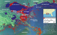
|
|
|
|
|
|
|
|
|
|
|
|
|
|
|
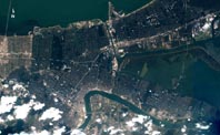
||||||||||||
|
|
|
|
|
|
|
|
|
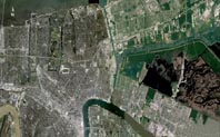
|||||||||||||||||||||||||||||||||||||||||||||||||||||||||||||||
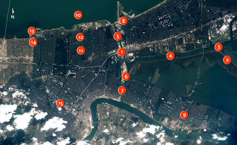
1. Katrina makes landfall in Louisiana at 6:10 a.m., but the flooding of residential areas in greater New Orleans actually begins an hour and a half earlier. Between 4:30 and 5 a.m., levees located where the CSX Railroad crosses the northern arm of the Industrial Canal, in the eastern part of Orleans Parish, breach. With metal gates normally used at this spot not working following damage during a train derailment, engineers had used sandbags to seal the levee "I" walls where the railroad passed through the walls. The ever-growing storm surge, which at this time of the early morning is about nine feet above sea level, breaks through these sandbags and begins flooding the city both to the east and west. 2. Before the storm's landfall an 18-foot surge with huge waves develops in Lake Borgne, peaking between 7 and 8 a.m. About two hours earlier, however, the westward-directed waves on the lake rapidly start eroding the levees fronting the Mississippi River-Gulf Outlet. (The MR-GO is a man-made waterway built to offer oceangoing ships a direct route between New Orleans and the Gulf of Mexico.) The MR-GO's levees, which make up the easternmost length of the ring of hurricane-protection levees surrounding St. Bernard Parish and the Lower Ninth Ward, are rapidly overwhelmed and in some places destroyed. The surge then roars westward into St. Bernard Parish, flooding all the lower areas of Chalmette, Meraux, and Violet, and reaching the Lower Ninth Ward by 6:30 a.m. 3. When Katrina makes landfall in Louisiana, it pushes a 14-to-17-foot surge of seawater up the Mississippi River as well as through the adjacent MR-GO and from Mississippi Sound through to Lake Borgne. The latter two surges coalesce in an area known as the "Funnel," so called because the levee systems go from being about nine miles apart to just several hundreds yards apart in the Gulf Intracoastal Waterway in the easternmost part of New Orleans. The loss over recent decades of nearby wetlands, which are natural absorbers of both wind energy and surge height during hurricanes, greatly exacerbates the surge now beginning to flood the city. In St. Bernard Parish, for instance, where marshes front levees, minimal erosion and breaches occur; where marshes are gone, the levees are wiped out. 4. At about 6:30 a.m., with the hurricane's eye still south of the city, the surge in the Funnel overtops the levees on its banks and starts to flood St. Bernard Parish on either side of the waterway. This exacerbates the flooding already coming from the MR-GO breaches. Floodwaters begin to rise even faster in the Lower Ninth Ward. 5. The surge flowing westwards through the Gulf Intracoastal Waterway races into both branches of the north-south-running Industrial Canal. Surge waters flowing south down the canal are stopped by the closed locks that separate the canal from the Mississippi River, while those flowing north pour into Lake Pontchartrain, which at this point in the early morning is still 10 feet lower in elevation. At about 6:50 a.m., the surge waters overtop levees all along the Industrial Canal, sending floodwater into the city to both the east and west of the canal. The Lower Ninth Ward takes a triple hit, having already been receiving floodwaters overtopping levees in the MR-GO to the east and Funnel to the north. 6. In the Industrial Canal, the floodwaters start to erode the earthen levee embankments and cause four sections of the concrete levee "I" walls to bulge outwards. Cracks appear on the concrete walls' canal-side bases. As the walls tilt or in some cases are even moved backwards, large cracks develop in the canal-side soil that underlies the concrete "I" walls. Water begins percolating down these cracks and under the pilings, weakening the soil foundation. The stage is now set for a major breach of the levee here and an even larger one a little farther down the canal. 7. Around 7:45 a.m., the levees along the eastern side of the Industrial Canal's southern arm breach explosively. A head of water almost 20 feet high destroys houses in the immediate vicinity of the breach and pushes others off their foundations. The Lower Ninth Ward begins flooding extremely rapidly, and a barge drifts through the major part of the breach, breaking the top nine inches off the already-failed concrete wall. All areas east of the breach flood to about 12 feet above sea level; since these areas lie below sea level, their houses are totally submerged. 8. Early in the morning surge waters cresting over the levee system in the northern arm of the Industrial Canal flood Orleans East. Later, around 10 a.m., floodwaters overtop levees along Lake Pontchartrain near the Lakefront Airport and gush for a few hours into Orleans East. The waters flow over a section of concrete levee that, strangely, lies almost two feet lower than the earthen walls to which it is attached. Also, a small portion of the earthen levee gives way here. 9. Once the eye of Katrina reaches the southern shore of Lake Pontchartrain, the surge in the Funnel and Industrial Canal levels off and begins to drain due to the storm's westerly winds. But the damage has been done. Besides the major breaches on the Industrial Canal, miles of levees along the MR-GO have been totally eroded, and St. Bernard Parish between the outlet and the Mississippi River has completely flooded. 10. As the eye of the storm starts to cross the Rigolets, a strait northeast of New Orleans that connects Lakes Pontchartrain and Borgne, the winds along the south shore of Lake Pontchartrain swing to the northwest. This drives highly turbulent surge water in the lake into canals opening onto the lake's south shore as well as against the levees lining those canals. 11. Surge waters from Lake Pontchartrain rush into the London Avenue Canal, continuing to rise until about 9 a.m. Far down the canal, near the Mirabeau Avenue bridge, the walls of the canal's levee, which consist of concrete walls atop earthen embankments, begin to swell outwards from the pressure. At appromixately 9:30 a.m., just after the peak of the surge, an eastern section of this levee fails catastrophically. Water drains into the city, lifting one home off its foundations and shoving it 40 yards across a road. 12. While the pressure on the levee walls in the southern portion of the London Avenue Canal eases after the breach, pressure farther north remains heavy. Levee walls just south of the Robert E. Lee Boulevard bridge begin to bulge outwards. About 10:30 a.m., the wall here fails on the west side of the canal, sending an eight-foot-high wall of water cascading into surrounding neighborhoods. This breach occurs even though the surge at the time is only seven feet above sea level, down three feet from the peak 90 minutes earlier. 13. Surge water floods into the 17th Street Canal at the same time as it does into the London Avenue Canal farther east. At the mouth of the 17th Street Canal, small homes and boathouses immediately west of the lake entrance to the canal fly apart, their debris blown into the waterway. Restaurants at the mouth of the canal along its eastern flank are also annihilated by the winds and waves, and some of this debris also enters the canal. 14. At about 10:30 a.m., the eastern levee of the 17th Street Canal bursts forth a few hundred yards south of the hurricane-proof bridge along the Metairie Hammond Highway. Eyewitnesses say the surge waters now flooding the western portion of Orleans Parish rise rapidly. As floodwaters continue to rush into the canal from Lake Pontchartrain, debris backs up against the low-slung Metairie Hammond Highway bridge.
15.
The catastrophic failure of the levee walls seals New Orleans' fate.
Designed to protect the city from a surge of at least 11.2 feet
above sea level, the walls failed with a maximum surge of 10.5
feet—thus, before their design criteria were exceeded. It
takes another two days for the floodwaters inside the city and in
Lake Pontchartrain to equalize to about three feet above sea level.
This leaves the average home in six to nine feet of standing water.
Investigations into why the levees failed have only just begun.
|
|
|||||||||||||||||||||||||||||||||||||||||||||||||||||||||||||||||
|
||||||||||||||||||||||||||||||||||||||||||||||||||||||||||||||||||
|
|
||||||||||||||||||||||||||||||||||||||||||||||||||||||||||||||||||
|