|
A 300-Year Struggle
|

|
|
|
Storm That Drowned a City homepage
|
| |

|
| |
The French explorer Jean-Baptiste Le Moyne, Sieur de Bienville made
a fateful decision in 1717 when he chose the site for New Orleans
along a sharp bend in the Mississippi River. Bienville selected the
site against the objections of his chief engineer, who realized that
the area suffered from periodic floods. New Orleanians have been
paying the price of Bienville's insistence ever since, from the
first major flood shortly after the town's founding to the merciless
juggernaut that was Hurricane Katrina. Here, follow the historical
trajectory of New Orleans' ever-worsening struggle to keep out
water.—Peter Tyson
|
|
|
|
|
A French foothold
1708
A Frenchman visiting the Mississippi River near what would become
New Orleans writes, "This last summer I examined better than I had
yet done all the lands in the vicinity of this river. I did not find
any at all that are not flooded in the spring. I do not see how
settlers can be placed on this river."
1717
The French establish "Nouvelle-Orleans" on the site of an erstwhile
Quinnipissas Indian village. (Indians first occupied sites in
eastern New Orleans around 500 B.C.) Like the Quinnipissas, the
French select the site because it's the highest and driest spot for
several miles around. Within a few years slaves are put to work
clearing land on the natural levee the French have selected for the
town.
1721
Surveyors lay down a grid pattern of streets of some 40 blocks, with
drainage ditches around each block and a dirt palisade surrounding
the town. A never-ending battle against high water—both
floodwaters and high water tables—has begun.
1722
Construction starts on a four-foot-high earthen levee (from the
French word lever, "to raise"), the beginning of three
centuries of combating high water through embankments. By 1726, the
levee remains incomplete, though a section fully 18 feet tall stands
before the Place d'Armes (now Jackson Square) in the heart of the
nascent town.
1732
After New Orleans floods in 1731, the town's Superior Council
mandates that all settlers along the river nearby build levees. By
1732, earth-and-timber embankments reach from 12 miles south of New
Orleans to 30 miles north on both sides of the Mississippi.
1752
Floods in the town remain troublesome throughout the 1740s, as city
engineers build their levees ever higher to cope with increased
flood levels brought on by changes in the landscape upriver. By
1752, landowners have added another 10 miles of levees beyond their
1732 extent.
|
|
|
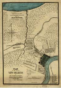
In this 1875 copy of a 1798 map of New Orleans, one can
roughly gauge the width of levees the French built along
Bayou Metarie (center left) and Bayou Gentilly (upper
right) by the extent of land on either side of the
bayous that is not marked by tree symbols.

|
|
|
|
|
Into American hands
1803
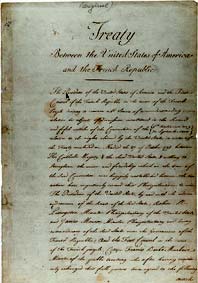
With the Louisiana Purchase, President Thomas Jefferson acquires New
Orleans and an additional 828,000 square miles of land in the
south-central U.S. from Napoleon Bonaparte. The purchase price: $15
million.
1811
The first steamship arrives in New Orleans. The town begins to grow
as an important trading center, serving as a critical link between
the world's oceans and 19,000 miles of river along 31 U.S. states
and two Canadian provinces.
1816
After a nearly month-long flood this year drives many poorer New
Orleanians from their homes, Edward Fenner, a noted New Orleans
medical authority, writes, "should not those in affluent
circumstances come to the aid of their less fortunate fellow
citizens, great indeed, we fear, will be the distress of the latter,
from poverty, famine, and perhaps pestilence."
1828
Another flood in New Orleans produces the highest water recorded up
to the time. The deluge sparks a renewed bulwark-building campaign.
Laws are now in place both regulating the dimensions and maintenance
of levees and mandating a tax to pay for their construction.
1846
Louisiana State engineer P. O. Hebert warns that New Orleans is in
"imminent danger of indundation" annually: "Every day, levees are
extended higher and higher up the river—natural outlets
closed—and every day the danger to the city of New Orleans and
to all the lower country is increased. Who can calculate the loss by
an overflow to the city of New Orleans alone?"
1849
Two topographic engineers describe the flood of 1849 as the most
destructive flood known. A breach in the levee on the east bank of
the Mississippi 18 miles above New Orleans does an "immense amount
of damage," they write, inundating the city for 48 days. Another
flood the following year convinces the federal government to grant
monies to build a continuous levee system.
|
|
|
The Louisiana Purchase Treaty secured the present-day
states of Louisiana, Arkansas, Oklahoma, Missouri, Iowa,
Nebraska, and North and South Dakota.
|
|
|
|
|
The levees-only policy
1850
By mid-century, city engineers agree that the best way to control
the Mississippi is to force it to flow down a single channel with
large levees on either side. The river will of necessity scour out a
deeper channel for itself, reducing the flood threat, they believe.
This becomes policy until 1927, when a disastrous flood in New
Orleans proves the folly of the policy.
1874
Four times between 1849 and 1874, a breach occurs in the Mississippi
River levee at Bonnet Carré north of New Orleans, each time
sending a flood towards the city at an estimated rate of 150,000
cubic feet per second. One commentator writes that floodwaters swept
away "dwellings, sugar-houses, crops, and fences, like chaff before
the wind," and even threatened the safety of the city itself.
1882
The worst flood in the Mississippi River up until this time opens
more than 200 breaches in the river's levees, most of them in
Louisiana, and keeps New Orleans at flood stage for 91 days. One
writer says this flood "left the people of the valley prostrate."
1883
In Life on the Mississippi, published this year, Mark Twain
scoffs at the Mississippi River Commission's flood-control mission,
writing that "One who knows the Mississippi will promptly aver ...
that ten thousand River Commissions ... cannot tame that lawless
stream ... cannot bar its path with an obstruction which it will not
tear down, dance over, and laugh at."
1893
A day-long assault of 30-foot waves overtops coastal levees and
destroys a fishing village south of New Orleans, killing 1,500
people.
1920
New Orleans is now the 14th-largest U.S. city, with a population
approaching 400,000. Improvements in drainage technology, foremost
among them a new screw pump invented by engineer Albert Baldwin
Wood, enable the city to start expanding northward toward Lake
Pontchartrain in the 1920s.
1923
The Army Corps of Engineers finishes connecting New Orleans to the
Gulf Intracoastal Waterway, a 1,300-mile canal stretching from Texas
to Florida. During Hurricane Katrina in 2005, this waterway will
unfortunately provide a direct route for storm surge into eastern
New Orleans.
1927
On April 29, with dangerously rising floodwaters in the Mississippi
threatening to overwhelm New Orleans, Louisiana's governor orders
the Army Corps of Engineers to dynamite a levee along St. Bernard
Parish, allowing floodwaters to drain across the parish's rural
neighborhoods and wetlands to Lake Borgne and the Gulf of Mexico.
New Orleans proper is saved, but the parish is devastated. More than
200 people die and 700,000 are left homeless. The disaster marks the
end of the levees-only policy; as one writer puts it, "a policy had
been breached and the pouring waters were sweeping an era away."
|
|
|
Workers strengthen a levee in the Third District, 1900.
|
|
|
|
|
Spillways and sprawl
1928
Congress acts swiftly to address the flood-control problem, passing
the 1928 Flood Control Act. Ostensibly the act says that the
Mississippi cannot be managed by levees alone, but also requires
spillways and reservoirs. The act authorizes the building of a
spillway at Bonnet Carré near Lake Pontchartrain to shunt
floodwaters away from New Orleans and into undeveloped areas.
1930
The wetlands between New Orleans and Lake Pontchartrain, which
provide habitat for wildlife, trapping and other livelihoods for
residents, and, perhaps most importantly, hurricane protection,
continue to disappear as the government drains them and people build
homes there. Marsh loss in southern Louisiana will reach 35 square
miles a year or more over the coming decades, a rate that by the
time Katrina hits in 2005 will have a severe impact.
1936
The 7,000-foot-long Bonnet Carré spillway is finally
completed. It includes 350 openings, each bearing 20 timber planks
that can be individually removed to increase flow out of the
spillway. Within a year it earns its keep, protecting New Orleans
from the flood of 1937 by sending floodwaters across a narrow strip
of land into Lake Pontchartrain. The spillway will successfully do
the same seven more times over the next 60 years.
1963
Corps engineers complete the Mississippi River-Gulf Outlet, a
76-mile canal that offers a direct route for ships between New
Orleans and the Gulf of Mexico, saving valuable time over traveling
up and down the sinuous Mississippi. But like the Gulf Intracoastal
Waterway, the canal also serves as a highway to New Orleans for
hurricanes and their storm surges.
|
|
|
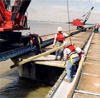
During a flood, workers can remove individual timbers
and place them atop the Bonnet Carré Spillway,
allowing for very precise release of floodwaters.
|
|
|
|
|
Hurricane season
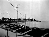
1965
Hurricane Betsy sideswipes New Orleans, killing several dozen and
becoming the first storm to cause more than $1 billion in damage.
Four parishes sustain significant flooding. "God, it was like one
giant swimming pool as far as the eye could see," one resident of
Chalmette recalled. "A woman who lives down the block floated past
me, with her two children beside her."
1969
From 1559 to 1969, 160 recorded hurricanes struck Louisiana, an
average of one hurricane every two and a half years. With the
state's and New Orleans' vulnerability to hurricanes in mind, as
exemplified by Betsy, the Army Corps of Engineers in the 1960s
develops its first hurricane-protection plan for the city and state.
1973
In April, the worst flood since 1927 hits the city. More than two
dozen people die, and damage is estimated at $427 million. But the
levees hold, preventing a much greater catastrophe. For the first
time in history, a major flood has been diverted successfully to the
sea.
1985
In response to Hurricane Betsy 20 years earlier, city engineers
finally approve hurricane-protection projects along the New Orleans
lakefront and in St. Bernard Parish. The projects include
strengthened seawalls and levees along the lakefront as well as
within the Industrial Canal and along the Mississippi River-Gulf
Outlet. The projects are 80 percent complete by 1994.
|
|
|
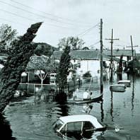
Hurricane Betsy flooded 164,000 homes when she swept
through the New Orleans area in September 1965.
|
|
|
|
|
Modern times
1988
New Orleans becomes America's number-one seaport in total tonnage
handled.
1995
Twenty inches of rain fall in a single day, causing seven deaths and
$1 billion in damage across three parishes. With an average rainfall
of 58 inches, New Orleans is one of the rainiest cities in the U.S.
And with the city having expanded into numerous low-lying areas, it
has become extremely vulnerable to floods not just from the river
and hurricanes but from its own protracted rainy season.
2001
Improved protection along the London Avenue, Orleans Avenue, and
17th Street Canals in Orleans Parish is 90 percent complete. The
improvements include lining the three canals with "I" walls and
building 10 flood-proof bridges where roads cross the canals. New
Orleans, it is thought, is now well prepared to withstand a Category
3 storm.
2005
Hurricane Katrina, a Category 4 storm when it makes landfall on
August 29, precipitates the greatest natural disaster in U.S.
history, killing more than 1,000 people, leaving 100,000 homeless,
and causing damage in the hundreds of billions of dollars. Most of
New Orleans is underwater as overtoppings and breaches occur in the
17th Street, London, and Industrial canals as well as along the Gulf
Intracoastal Waterway and Mississippi River-Gulf Outlet. (For more
details, see
How New Orleans Flooded.)

|
|
|
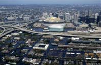
In the wake of Hurricane Katrina, New Orleans' Superdome
served for countless displaced residents as an island in
a sea of inundation.
|
|
|
| |
Further Reading
Transforming New Orleans and Its Environs: Centuries of Change
Craig E. Colten, editor. University of Pittsburgh Press, 2000
Land's End: A History of the New Orleans District, U.S. Army
Corps of Engineers, and Its Lifelong Battle With the Lower
Mississippi and Other Rivers Wending Their Way to the Sea
by Albert E. Cowdrey. U.S. Army Corps of Engineers New Orleans
District, 1977
|
|


|
|
|
| |
|
|
|