 |
 |

|
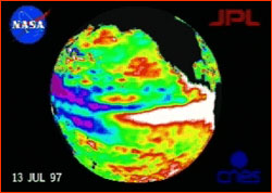
(back) How does El Niño take over such a huge system? It begins with an effect due to the vastness of the Pacific Ocean itself, an effect intimately related to the birth of an El Niño. In the Pacific near the equator, the prevailing winds blow from east to west, as cool air sinking from higher latitudes toward the equator gets whipped sideways by the Coriolis force. We know these as the tradewinds, which sailors of old could always depend upon to blow steadily in the same direction. In the tropical Pacific, these west-blowing tradewinds push steadily against the sea for thousands of miles. The warm water on the surface is literally blown sideways, and the water piles up in the west, creating a pool thousands of miles across. This leads to a heat imbalance: as more and more warm water is stripped from the east and moved west, cold waters from deep in the ocean near South America are drawn up to take its place. This cool water inhibits evaporation and the creation of rain clouds in the east, which is why the Galapagos Islands and the coast of Peru are
Here's where it gets interesting, the crux of the mystery of El Niño. This cycle should be self-perpetuating. But it's not. For unknown reasons, every few years, something hidden in the machinery causes the west-blowing tradewinds to slacken in the Pacific. The warm waters, which have been held by the winds in a pile 5 feet above sea level in the west, begin to flow back across the sea, drawn down by gravity, like a river breaching a levee. This massive surge of heated water shoots across the ocean and repositions itself near South America. East becomes west. Because of the heated water, all of the rainmaking that normally would happen in the west now happens in the east, and the convection cell reverses flow, which means rising warm air in the east sucks in the air from the west, and the tradewinds actually reverse their direction. Because the water in the west is now comparatively cool, rainmaking stops. The monsoons fail in Indonesia, but unending rains begin in Peru. The Child has arrived. In its new, temporary headquarters off South America, the warm pool's heat again creates a huge mass of warm moist air, which bulges into the zones of prevailing winds at the surface as well as high in the air. Like a car
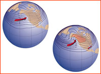
After lurching north, the jet stream (like everything else in the system) tries to compensate for its too-far north motion by diving south, usually over the Rocky Mountains. It then snakes north again, creating the classic El Niño pattern. Because the jet stream represents a boundary between cold northern air and warm moist southern air, meteorologists are able to make general predictions for weather in an El Niño winter. For starters, Pacific storms form farther east than usual. The northward bulge of the jet stream then conducts these abnormal storms into California and Mexico. Meanwhile, normal winter storms that would otherwise be steered through Washington and Oregon now veer northward toward the coast of Alaska, eventually being guided east into Canada. The west coast gets drenched; the Canadian Rockies get record snowfalls.
You can also see on the diagram that in the midwest and northeast, the jetstream's strange dip and rise keeps colder Canadian air stuck in Canada, far north of its usual winter position. Acting as a boundary between this cold northern air and mild southern air, the displaced jetstream lets Chicago and New York enjoy a relatively warm, if somewhat wet, winter. Because the rain machine in the west stops working, southeast Asia and Australia suffer devastating droughts. Meanwhile, North and South America get drenched, because the rain machine in the east is working overtime. Farther downstream in the great wind bands that circle the globe, El Niño continues to create havoc. By using the bands of prevailing winds as avenues along which to transmit its disruptive waves, El Niño eventually influences weather in Africa, the North Atlantic, even the Middle East. Teleconnected to distant regions by the Earth's rivers of air, El Niño invades the global weather machine. See El's Niño reach across the globe. Anatomy of El Niño | Chasing El Niño | El Niño's Reach Dispatches | Resources | Mail | Site Map | El Niño Home Editor's Picks | Previous Sites | Join Us/E-mail | TV/Web Schedule About NOVA | Teachers | Site Map | Shop | Jobs | Search | To print PBS Online | NOVA Online | WGBH © | Updated November 2000 |
||||||||||||

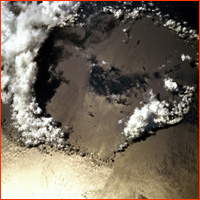 Clouds and warm moist air billow upward from a heated sea. In this NASA Space Shuttle photo of a section of the tropical Pacific, clouds condense in the rising air mass created by contact between the ocean and the atmosphere.