 |
 |

|
 Global Weather Machine
by Mark Hoover We live in an ocean of air, seething and flowing around us, changing-sometimes violently-every day. In the heart of this swirling machinery of rain clouds and jetstreams, hot desert winds and frozen arctic storms, there is one constant: change. A trillion and a half days have passed since the Earth was born in a spinning disk of stardust, and no two of those days have ever had the same weather. Driven by the heat of the sun, weather is an interlocking system of cycles. Water evaporates, rises, cools, and falls as rain, only to evaporate once again. The sun rises and sets every day, with the air warming and cooling in response, and the cycle endlessly repeating. Low pressure systems suck high pressure systems into their vacuum, creating spinning masses of wind
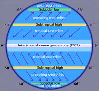
Because the Earth is a globe, and not a flat board, the sun shines almost straight down on the tropics, baking them every day of the year. But at the poles, the angle is small and the sun's rays are weak, and the poles are therefore cold. Nature "abhors" this imbalance, and tries to fix it. As quickly as solar heat flows in to the tropics, it begins flowing out toward the poles, seeking to equalize the difference. The unrelenting march of this energy-on-the-move, from high concentration to low concentration, is the piston in the engine that propels weather. When warm air leaves the tropics and heads toward the poles, cold air from near the poles is sucked back toward the tropics. This exchange sets up two-lane highways for air rushing to and from the tropics. These highways of air are called convection cells, and they are the reason wind blows.
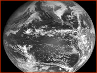
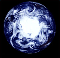
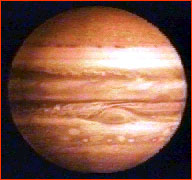
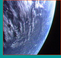
We can see these bands of wind clearly in Jupiter's atmosphere, because Jupiter rotates at a furious pace, once every ten hours. We can also see them clearly on Earth when we take a picture from far out in space. El Niño exploits this organization of winds into bands when it causes major weather changes around the world. Specifically, El Niño can affect the path of flow in these bands, and the cyclones that are ushered across the surface by them are now delivered to different areas than normal. Think of the wind bands—both at the surface and high in the sky—as a tram, a streetcar on which storm systems hitch a
Continue: How does El Niño take over such a large system? Photos/Illustrations: (1) NASA; (2) University of Illinois WW2010 Project; (3) NASA/JPL; (4) NASA; (5) National Center for Atmospheric Research/Scientific Computing Division: Sponsored by the NSF. Anatomy of El Niño | Chasing El Niño | El Niño's Reach Dispatches | Resources | Mail | Site Map | El Niño Home Editor's Picks | Previous Sites | Join Us/E-mail | TV/Web Schedule About NOVA | Teachers | Site Map | Shop | Jobs | Search | To print PBS Online | NOVA Online | WGBH © | Updated November 2000 |
||||||||||