
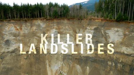
Killer Landslides
Explore the forces behind deadly landslides—and the danger zones for the next big one. Airing September 6, 2017 at 9 pm on PBS Aired September 6, 2017 on PBS
- Originally aired 11.19.14
Program Description
Transcript
Killer Landslides
PBS Airdate: November 19, 2014
NARRATOR: A sudden landslide…
RICHARD IVERSON (U.S. Geological Survey): Nobody anticipated that it would cut loose and bury that entire village.
NARRATOR: …some victims are buried alive; others narrowly escape.
REVERAND ROBIN YOUNGBLOOD (Landslide Survivor): I saw a gigantic wall of mud, and then we were hit.
AMANDA SKORJANC (Landslide Survivor): Houses were exploding.
911 CALLER: Oh, my gosh!
911 DISPATCH: Are there any injuries?
911 CALLER: Yes! There are people yelling for help!
NARRATOR: A whole community is cut off.
DAYN BRUNNER (Brother of Woman Lost in Landslide): What's going on with the highway? I'm hearing rumors that there's a mudslide.
NARRATOR: A neighborhood, wiped from the face of the earth, is invisible to rescuers.
BILL QUISTORF (Chief Pilot): All I could see was just a vast wasteland. There were no homes. There were no remnants of homes.
NARRATOR: Volunteers risk their lives to extract the missing from the mud.
DAYN BRUNNER: It was so eerie. We could hear moaning. We walked past four bodies.
ROBIN YOUNGBLOOD: He was just drenched and shivering and shaking.
NARRATOR: What could have triggered the tragedy?
ERNIE ZELLERS (Rescuer): Where's the baby?
AMANDA SKORJANC: I thought I was losing him. And I'd say, "Stay with me, Bud!"
NARRATOR: Can science explain how Earth can turn to liquid in an instant?
RICHARD IVERSON: Everybody feeling ready for go time here?
GEOLOGIST: Okay, we're ready for water? Here it goes!
DAVID MONTGOMERY (University of Washington): It was something like 22 inches of rainfall. You know, that's almost two feet of rain, in a month.
NARRATOR: Some of these disasters are triggered by rain, but not all. Around the world, scientists fear that landslides could be on the rise. Now, geologists are hoping to spot the next big one before it strikes, to warn those in its path, and avert further loss of life.
DAVID MONTGOMERY: There's no word for it other than "tragedy."
NARRATOR: How far out can we predict landslides?
LORENZ MEIER (Physicist): The closer you get to an event, the easier it gets to predict it.
RANJAN KUMAR DAHAL (Geologist): It will be a very big one, huge one!
NARRATOR: The race is on to sound the alarm and save lives from Killer Landslides, right now, on NOVA.
Late March: record-breaking rains have hit western Washington. 10:30 a.m.: families are enjoying the first sunny weekend of spring. It's been raining for months.
In an instant, this idyllic morning becomes a nightmare. The saturated earth on a slope nearby starts to slip. A landslide comes plummeting across the valley towards the unsuspecting families.
AMANDA SKORJANC: The sound is like this horrible, rumbling, wet…I turned, and I held Duke, and I did not let him go.
NARRATOR: Sitting at her table with a friend, Reverend Robin Youngblood has no time to escape.
ROBIN YOUNGBLOOD: We heard this horrible sound. It sounded like a 747 was going to crash in the valley.
NARRATOR: Half a mile away from Robin's home, Amanda Skorjanc is in the kitchen with her five-month-old baby, Duke.
AMANDA SKORJANC: The sound is unexplainable, and I, I will never get it out of my head.
ROBIN YOUNGBLOOD: We ran to the window, when we heard that sound, and I looked to my right, and I saw a gigantic wall of mud. And then we were hit.
AMANDA SKORJANC: And it was like a movie. Houses were exploding. And the next thing I remember is our neighbor's chimney coming into our front door.
RICHARD IVERSON: Everything that was in its path, essentially, it picked up and was throwing in front of it: trees, debris from houses. It would be like being hit with a thousand battering rams at once. It was just a completely unsurvivable sort of event.
ROBIN YOUNGBLOOD: We were slammed, and we were under water and mud. The house was racing across the valley, and, and then we stopped.
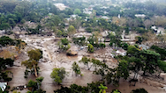
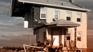
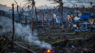
NARRATOR: Without warning, this hillside turned to liquid mud, wiping out 49 homes.
The slope collapsed, but it didn't stop there. It dammed the river and continued on to rampage through a neighborhood, reached highway 530 and kept going. All is now a wasteland of mud and debris: one square mile buried under 15 to 75 feet of mud.
911 DISPATCH: Nine-one-one, what is your emergency?
FEMALE 911 CALLER 1: There's like a mudslide and everything is gone! The houses are gone!
MARLA SKAGLUND JUPP (Landslide Survivor): (911 call) There is a house on 530, and it is covering the road!
I was standing here, and I heard this noise, and I looked out, and it sounded like a big truck. And then my lights went out.
MALE 911 CALLER 1: My neighbor's house has been completely taken out, and it's collapsed on several of them, and they're trapped.
FEMALE 911 CALLER 1: Oh, my gosh!
MARLA SKAGLUND JUPP: So, I walked out the front door, and then I looked up the road, and then I knew what it was. I could see the, the stuff in the road, and then I knew it was a slide. Took my phone out of my pocket and dialed 911.
(911 Call): There was a big landslide at the bottom of Skaglund Hill!
NARRATOR: It's only minutes after the landslide buries nearly a mile stretch of highway 530. Everything in its path, in a tiny community called Oso, is altered forever. Rescuers have no idea if there are any survivors.
MARLA SKAGLUND JUPP: It didn't take very long for the guys to come from Oso. They were here within 10 minutes.
MIKE BLANKENSHIP (Oso, Washington Fire Department): When you could see dirt for a mile straight, you knew you were in for the long haul.
DAVID MONTGOMERY: This slide apparently happened in 138 seconds from start to finish, in two phases it seems, based on the seismic signal that was recorded at the seismographic station at U.W.
NARRATOR: If scientists converted these seismic waves to sound waves and sped them up, this is how they would sound.
The initial collapse registered on seismographs a hundred-and-seventy miles away.
DAVID MONTGOMERY: Imagining all that material moving off that valley wall, all the way across the valley floor in about two minutes? I mean, that's really hard to imagine.
PAULO FALCAO (Landslide Witness): Oh, my gosh. Look at this!
NARRATOR: The danger is not over for the victims or rescuers. Another part of the hillside could break free and come crashing down. Some landslides strike twice.
Around the world, landslides occur anywhere there's elevated terrain, killing thousands of people every year. In just seven months, 222 landslides worldwide caused loss of life, resulting in nearly 1,500 deaths.
WOMAN (Landslide Witness): Oh, my god!
NARRATOR: They occur in every U.S. state and cost billions annually.
A landslide is simply a downhill movement of earth, rock or debris…
VOICES: Oh! Oh!
NARRATOR: …triggered when gravity overpowers the binding strength of the materials that make up a slope.
Some landslides are slow and shallow. The top layers of soil or rock slip over time, just inches or feet a year. Others, like mud flows and rock falls move rapidly and can flow long distances. Rapid, deep landslides that travel far, like the one in Oso, are the most dangerous and difficult to predict.
DAVID MONTGOMERY: If you think about the distinctions between landslide types, the sort of deep-seated landslides and shallow landslides, shallow ones usually involve just the soil, or what we call the "regolith," the weathered stuff on top of rock. Shallow landslides will often involve, like, a meter or maybe a couple meters.
The one behind me is a deep-seated landslide. The whole valley wall came down.
NARRATOR: The raw slope left behind after a landslide is called a "scarp." David Montgomery is a geomorphologist who studies landforms and the forces that shape them. He begins his investigation at Oso by surveying it from a distance.
DAVID MONTGOMERY: You can kind of get a sense for how that old edge of that plateau dropped down as part of the landslide, but you can also see at the bottom how the toe of the slide, the bottom of it, spread out laterally, across the valley bottom. So this solid hillside started to fail, and then it fluidized, it turned into a debris flow.
This is a super-big landslide that travelled super-fast. It's really hard to relate to that in human terms.
NARRATOR: Even now, days after the Oso landslide, chunks continue to calve off.
GEOLOGIST: That's a big one. Wow!
NARRATOR: This slope has slid many times before.
GEOLOGIST: Whoa!
NARRATOR: To figure out if it could slide again in the future, Dave needs to look into the past. A technique called "lidar," laser-based altimetry that can penetrate through the tree canopy, reveals the scars left behind by past landslides.
DAVID MONTGOMERY: You basically take a laser and mount it in a plane, fly it around and shine it down on topography and measure the time it takes for the returns to get back to the instrument. So, you're basically scanning the topography below wherever you have the instrument.
NARRATOR: This lidar image shows the contours of the Oso valley before and then after the March 22nd landslide. It also shows evidence of past landslides up and down the valley. The yellow landslides are the oldest, followed by the tan and orange ones, which overlap them. The red slides are the most recent, with the crosshatched one designating the March 22nd event.
It wasn't the biggest landslide to strike the region. The large orange landslide, that probably slid many centuries ago, is nearly twice the size of Oso's recent slide. The challenge is to figure out how long ago and how frequently landslides occurred.
DAVID MONTGOMERY: That requires, sort of, good old-fashioned geology. You need to go out and try and find something to date.
NARRATOR: David Montgomery and his team found they could readily date the ancient landslides.
DAVID MONTGOMERY: This is one of the buried logs that we carbon-dated at about 5,300 years. It's buried in an old landslide deposit. How'd we date it? You grab a piece of bark, take it back to the lab. We got three carbon samples out of this margin of the slide, all dated to about 5,300 years, carbon age.
NARRATOR: Since 1933, aerial photos and satellite images have provided even more clues about the history of the slope. Pictures show the Oso slope slid repeatedly, changing the course of the river at its base. The regrowth of vegetation hid the scars of its unstable past.
DAVID MONTGOMERY: You have this pattern with this slide, on that slope, of essentially failing, and then being quiescent for a while, then failing again, a decade or two later. So this slope was a known actor, in terms of landslides that happened periodically, involving just the lower part of the slope that eventually failed in 2014.
NARRATOR: Although rescuers in the region train for landslide disasters, no one was prepared for this kind of devastation.
911 DISPATCH: We have requested a helo from the Navy and from our Search and Rescue.
NARRATOR: The Snohomish County Helicopter Rescue Team was first air support on the scene.
RANDY FAY (Crew Chief): Check.
NARRATOR: They use advanced technology to search for survivors. Scanning the mudscape with an augmented reality mapping system, pilots toggle between the mud-grey live video, which is inset into the green pre-disaster aerial photography, showing where the 49 homes once stood, where streets were laid out, just an hour earlier.
BILL QUISTORF (Chief Pilot): The partner that I was flying with, our tactical flight officer, he told me right off the bat that there were 30 homes in the area. And I said, "Thirty homes? Where?" Because all I could see was just a vast wasteland. There were no homes. There were no remnants of homes.
NARRATOR: A thermal camera allows them to spot bodies by the heat they give off.
BILL QUISTORF: This tool was vital in helping us search and determine that there were no live people in the mud.
NARRATOR: They expected to find people near where their homes once stood, but the instrument detected no heat signatures at all. There was no longer anything there: no houses and no people, dead or alive.
A geologist helped them to refocus the search.
RICHARD IVERSON: It took a bit of time for this to sink in with us, because we were thinking one way, whereas the searchers were, by and large, thinking another way. Being trained as first responders, they had the mindset that the place you needed to get to was the place where those people had been, meaning where the houses had been before the landslide occurred. It was immediately clear that there was going to be nothing there. There would be no trace of civilization whatsoever back where those houses originated.
NARRATOR: When the hill collapsed with such force, it pushed all the debris, houses included, to the far side of the valley. It's what scientists call the "distal end" of the landslide.
Richard Iverson was able to map out the direction the landslide and anything caught up in it would go.
RICHARD IVERSON: This was an incredibly real manifestation of something that I'd been studying on a more abstract level for decades. And to see it all play out, right there, and witness firsthand the damage that it had wreaked…it was really a very, very profound experience.
NARRATOR: The next time a landslide strikes, geologists, first on the scene, could be instrumental in saving lives.
Robin Youngblood's home was rafted hundreds of feet from where it once stood.
ROBIN YOUNGBLOOD: I was still conscious. I couldn't breathe. My nose, my mouth, my ears, my eyes, everything was full of water and mud. I knew I had to get out. I don't know quite how I knew which way was up. And I started pushing, and finally I got air.
RANDY FAY: Robin and her friend were the first ones we spotted. They had gotten on top of the debris of Robin's home and were waving and caught our attention.
The methodology we use for them involves putting them in a hammock device, so they don't have to move or really participate. And as long as we're comfortable there's no spinal injuries of any kind, we can get them out of there pretty quickly.
ERNIE ZELLERS: I have her. Give me some slack! Are you okay?
ROBIN YOUNGBLOOD: They dropped us off and said, "We're going right back. We saw somebody."
RANDY FAY: Our crew chief spotted something moving in the mud.
NARRATOR: It was four-year-old, Jacob Spillers, struggling alone in the mud. He was home with his father and three siblings, Brooke, Kaylee and Jovon, who were watching T.V. downstairs, while their mother was out. Jacob was on the second floor. The landslide carried him over a quarter of a mile away. All but Jacob were buried alive.
RANDY FAY: Jacob, at that point, was about waist deep in this and covered head to toe with mud, and so it was just kind of the wriggling around. So, had we not come down lower and slower to watch that, well, I don't think we would've spotted him, frankly.
NARRATOR: A neighbor miraculously made it through the mud to Jacob. But now they're both stuck.
RANDY FAY: It was clear, if he was sinking, as a four-year-old, a big fat guy like me was going to have real trouble.
NARRATOR: Jacob is hypothermic. His rescuer shields him from the helicopter's rotor wash.
STEVE KLETT (Pilot): We attempted to come down and put a skid close to a log, and there just was not enough rotor clearance to get down that low.
RANDY FAY: We do a maneuver called "low hover off-loading," and we do this in the mountains a lot, if we're working against ledges or areas where we can't land. And it basically involves bringing the helicopter down to a one-foot-hover next to an obstacle, and then we move on and off the aircraft, while the pilots hold it steady there.
I sank probably a little over ankle deep, when I stepped off and was hesitant to move down the slope, for fear I'd get stuck. So I had a hand line that I threw him. And between the two of us we were able to pull them up out of there and get them up with us.
We handed Jacob to the crew chief, and then the other gentleman turned to leave and immediately started sinking again. So I motioned for him to come back up. We put him onboard, and he actually held Jacob while we flew out of there, which turned out to be a good thing that he was onboard with us.
ROBIN YOUNGBLOOD: They brought Jacob to us in the ambulance, and he was just drenched and shivering and shaking, and, I mean, I'm a grandma, right? So, I just told him, "I'm going to get those wet clothes off you. We're going to put you in a warm blanket. I'll take care of you. We're going to sing songs. It's okay."
NARRATOR: The scope of the devastation caused by this landslide is something that even a trained geologist like David Montgomery has a hard time accepting.
DAVID MONTGOMERY: Wow. You know, who would've been able to imagine that on the very first nice day of spring the whole mountain could come down and run all the way across the valley bottom?
NARRATOR: He wants to see for himself the distal end of the slide, the place where houses, people, cars and the remains of an entire neighborhood ended up, bulldozed by the landslide.
Seeing ground zero is a shock.
DAVID MONTGOMERY: What can you say? It's utter devastation. We're at the distal end of the debris flow, and you can see that the jumble of wood and soil that was pushed as the leading wave of the debris flow, that ran into the highway and everything in between the slide, and with unimaginable force, completely torn up, in a chaotic pile of debris. But notice all the wood from the trees that were entrained that were pushed along within the flow got rafted out to the front.
I've seen deposits from debris flows before, but never anything this big and this extensive. It's, it's unimaginably large. The scale of this is just overwhelming.
NARRATOR: What's surprising to the experts is that a 600-foot-high slope slid for a mile, many times further than this slope ever slid before. It's a central mystery of the disaster, something no one expected.
RICHARD IVERSON: If the Oso landslide had behaved in an ordinary fashion, it might've hit one or two houses. That's, of course, not what happened at all. Instead, the landslide mobilized and very dramatically ran on the order of five times further than you might've expected, based on typical behavior. And that's what really lead to all the devastation.
NARRATOR: David Montgomery gears up to investigate what's behind this deadly anomaly.
DAVID MONTGOMERY: We are going over to the scarp of the slide, which has been actively eroding since the failure. And we want to be roped in and as safe as possible getting close to the thing.
PETE ATHANS (Mountaineer): Dave, have you put on a harness before?
DAVID MONTGOMERY: I've had them put on me before.
NARRATOR: He's roped to four anchors for safety. At any moment, with his weight adding stress to the top of the landslide, a chunk, with Dave on it, could peel away.
DAVID MONTGOMERY: You can hear the ravelling off the face. The sediments that are exposed in the head scarp of the landslide are sand and gravel. It's fairly loose stuff, and you can hear the individual particles being dislodged and rolling down the face, as we stand here. You can actually see the stuff coming down. You can see the plumes of dust rising up off of the scarp.
NARRATOR: The loose sand and gravel can't adhere to the scarp, so it easily slides off the slope.
DAVID MONTGOMERY: This is safe enough that we are roped in. The head scarp has been retreating back since the landslide happened. It's fairly weak material. We're obviously hoping that doesn't happen very soon.
NARRATOR: What was the top of the slope before the landslide is now nearly 300 feet below the head scarp.
DAVID MONTGOMERY: The area downhill from here that has all the trees on it that have been back-rotated is a big block of the landslide that dropped out from under, just in front of us, and was, essentially, the head of the slide, forming this head scarp.
NARRATOR: The Oso landslide came down in two pieces: the lower half of the slope that spread out onto the valley floor, and the heavily-treed head scarp that plummeted halfway down the slope; two events, just minutes apart.
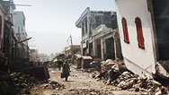
The same thing happened in Afghanistan, just a few weeks after the Oso slide, while a wedding took place in Badakhshan. Two slides with long runouts came crashing down in succession, when rain turned a mountain to liquid mud.
The first slide crushed homes in an instant. Eyewitnesses raced into the deadly mire, desperately trying to dig out family members, when the second slide hit minutes later, much larger than the first. Hundreds, perhaps thousands, are entombed in more than a hundred-and-sixty feet of mud.
The government declared the site a mass grave.
HAJI MOHAMMAD JAMSHID (Head Engineer, Ministry of Mines): It's really hard for survivors to find their homes using simple tools like shovels. We haven't recovered any of the deceased in the mud.
The people are horrified. They witnessed the tragedy with their own eyes. They describe the landslide as if it were a monster that devoured their loved ones.
DARI ZIA-ULHAQ (Landslide Survivor): My family, including my child and all my belongings, are gone. We ask the government to help us here. We don't have the necessary equipment.
HAJI MOHAMMAD JAMSHID: Some people whose houses weren't destroyed still won't return to their homes. They'd rather live in temporary tents than face the horror and fear of another landslide.
NARRATOR: Geologist Haji Mohammad Jamshid found evidence of cracks at the top of the mountain, a known first indicator of movement on a slope.
HAJI MOHAMMAD JAMSHID: This shows an opening in the earth that is 10 meters deep, and the width is between one and three-point-five meters wide.
NARRATOR: With better landslide awareness, these obvious signs on a slope above a populated area can raise red flags, in time for authorities to set up a monitoring system.
HAJI MOHAMMAD JAMSHID: It's not possible for human beings to prevent natural disasters. But we can save people by evacuating them from landslide-prone areas.
DAVID MONTGOMERY: The unfortunate reality is that sometimes, if part of a slope fails, it can destabilize the next piece. Sometimes two happen in very rapid succession, like the most recent Oso slide and like the Afghanistan slide. And that can be really heartbreaking, if you have people doing the very human thing of rushing to help, and then those people get caught in the second bit. There's no word for it other than "tragedy."
NARRATOR: Understanding why a landslide behaves the way it does is almost like investigating a crime scene. Geologists have to search for clues, like the composition of the soil that slid. Dave Montgomery peels back the layers of the Oso slope. It all dates back to when glaciers were here, 15,000 years ago.
DAVID MONTGOMERY: This material is the glacial lake deposits that are at the bottom of the geological pile here. And it's a mix of silt and clay that I can just crumble with my fingers.
NARRATOR: When wet, the very fine material that makes up this base layer of clay slips like a banana peel. The layer above it is a porous silty sand. Water drains through it like beach sand.
DAVID MONTGOMERY: These gray pillars around me are all made out of glacial till, which came off of the head scarp. And the stuff is pretty strong. It's pretty cohesive. It holds together well. It survived the trip down to here in fairly large chunks.
NARRATOR: Glacial till is an upper layer of hard packed material, left behind by the compressing action of a glacier from the last ice age. It's the layer just beneath the very loose sand and gravel at the top.
DAVID MONTGOMERY: And we know it's till because there's boulders, there's gravel, there's pebbles, there's sand and there's clay. It's everything. It's like a dog's breakfast of a deposit.
NARRATOR: Add to that a regular flow of groundwater.
DAVID MONTGOMERY: How much of that water was actually flowing into and helping to saturate the material that failed in the 2014 landslide is an open question. But there was certainly groundwater coming in from the margins of the slide.
NARRATOR: How much water the layers on each slope can hold is a factor landslide geologists try to measure.
RICHARD IVERSON: The contributing factors in the great majority of landslides have to do with water. In the case of this event, at Oso, there had been prolonged heavy rain. The wetter it is, the more likely it is that the groundwater pressures will tend to build. And it's that increase that eventually triggers the landslide.
NARRATOR: Layers of clay, sand, glacial till, and a loose, gravelly top layer are typical materials found, worldwide, on mountain slopes. This combination of ingredients, mixed with a wet climate, paves the way for a long runout landslide.
DAVID MONTGOMERY: You have the geological set up of a naturally unstable slope, and then we get a very, very wet winter. The proximal cause of this landslide is we had the wettest March in history, something like 22 inches of rainfall in this area. It's almost two feet of rain in a month.
MIKE BLANKENSHIP: I live in Washington. So, it rains a lot in Washington.
NARRATOR: The Pacific Northwest is landslide country. More rain falls here than any other part of North America, as much as 118 inches annually on the western slope of the Cascades. Research suggests climate change could result in an increase in the number and intensity of showers. This could cause more frequent landslides on unstable slopes.
But Oso experienced a slide beyond expectation, and scientists want to know what caused the mountain to turn to liquid so quickly and flow so far.
Richard Iverson has studied debris flow for 30 years.
RICHARD IVERSON: When we first arrived on the site and looked out across the area of devastation, it really didn't make sense. You don't expect a landslide originating from that height to travel that kind of distance. So, immediately that poses a big question in your mind, scientifically, as to why this thing travelled as far as it did.
NARRATOR: The unique physics of the landslide was the result of a phenomenon Iverson knows well, when the ground turns to liquid, in what's called "liquefaction."
RICHARD IVERSON: Usually, when people hear the word liquefaction, they think of something that occurs during earthquakes, because when the ground shakes and you have loose wet soil, that soil can liquefy and buildings can become destabilized. But it turns out that landslides can also cause liquefaction.
NARRATOR: Iverson's models help illustrate just how fast a rapid deep landslide, now liquefied, can move. He believes Oso's 7,600,000 cubic meters of mud was moving at 60 miles per hour.
RICHARD IVERSON: It took less than one minute for the debris to move from the source area, here, all the way across the floodplain. That's a distance of roughly one kilometer. Here's the scale.
And then for some extended period afterwards, it gradually oozes out along the margins.
NARRATOR: Virtual Oso provides some answers, but what if we could recreate a real landslide to learn how far and fast it'll go?
In Oregon, Richard Iverson oversees experiments at the world's largest landslide flume, a 310-foot-long concrete chute. Here, the U.S. Geological Survey slops together truckloads of soil materials to track how they behave when water is added. This is how geologists here study the forces of nature. They want to figure out how much rain is too much, on slopes like Oso.
RICHARD IVERSON: The experiments are actually very pertinent to what happened at Oso. We put a pile of loosely-packed sediment in the top of our flume, and we simply water it until failure occurs. The landslide will liquefy, because of the loose packing configuration or the high porosity of that soil.
NARRATOR: Porosity is a measure of how much open space there is between the individual particles that make up soil. Loose soil is more porous than tamped-down earth.
RICHARD IVERSON: If the soil were more densely packed, then it would have much less inclination to liquefy.
NARRATOR: Iverson and his colleagues will measure how long it will take to turn this solid mass to liquid.
RICHARD IVERSON: Everybody feeling ready for go time here?
GEOLOGIST: Okay, we're ready for water.
NARRATOR: Playing Mother Nature, the team adds rain to Mount Flume.
RICHARD IVERSON: It's very much like an Oso-type landslide being triggered by long-term, accumulating rainfall and building groundwater pressures.
NARRATOR: Cracks, showing slippage at the top of the slope, soon form in the loose rock and soil mixture. The porous slope takes on water like a sponge.
RICHARD IVERSON: Rocks and soil are an amazing thing in terms of how they respond to water. One slope can take on water faster than another one can.
NARRATOR: Instruments relay 7,500 measurements a second.
RICHARD IVERSON: We're going to have something like 70 electronic sensors deployed in each one of those experiments and some of those will be measuring deformation of the slope internally, as it begins to creep and fail; others will be measuring the water pressure; some will be measuring the surface displacement. So, it's really quite a chaos of cables when we run one of these.
NARRATOR: This is one instance where "failure" means success.
Ninety-two minutes after applying five inches of simulated rain, the solid slope liquefies.
RICHARD IVERSON: We've learned a great deal from being able to witness these things hundreds of times over, in our flume. There's really no substitute for seeing things firsthand to spur your thinking and make you understand, on an intuitive level, things that are otherwise quite abstract in the way of physical concepts. It's a real big part of doing physics, frankly, to have a deep intuition about things in addition to simply doing the math.
NARRATOR: After the first mini-slide of liquid mountain, Iverson doubles the rainfall, to trigger an even bigger landslide.
RICHARD IVERSON: First, we had a relatively shallow slope failure that's typical in many mountainous areas. But then, after that, we continued to add water to the slope, eventually triggering a much deeper-seated failure, where the material liquefied when it failed. And then we got a much larger debris flow mobilizing.
GEOLOGIST: Here it goes!
NARRATOR: Heavy rain and porous soil makes the particles behave like ball bearings. They lose their cohesive strength and become liquid earth.
RICHARD IVERSON: And that, in effect, is our attempt to simulate what happens when you have prolonged rain that sets the stage for landsliding.
NARRATOR: Flume experiments, like this one, could help refine models to predict the length and speed of future landslides and even guide search and recovery teams.
The immense area affected by the Oso landslide requires an extraordinary effort. More than 900 people were involved, many working alongside a hundred-and-twenty-three rescue dog teams to recover those presumed dead, sifting through every inch of the one-square-mile mudscape.
LEUITENANT BOB VANDER YACHT (Public Information Officer): There are still seven humans that have not been located. There is not a worker out there that is going to want to stop doing the search until they've found everybody.
BROOK ALONGI (Rescuer): At this point, it's not everybody on their hands and knees digging through the mud and the sticks.
NARRATOR: Search zones are delineated, like an archaeological dig.
BOB VANDER YACHT: The efforts are very meticulous. They're using a grid pattern. It has an excavator with an operator, dog teams, spotters.
BROOK ALONGI: And when they pick it up, they don't just drop it, they gently drop a little bit, and we watch every little thing that falls out.
NARRATOR: It's a fine-tuned protocol using proven search tactics.
BROOK ALONGI: In the areas that I was searching in, most of the two-by-fours were reduced to pieces this big. And then you find a couch that's in a million pieces, and then you find a tractor that's broken in half. Trucks were ripped into five, six pieces, diesel trucks! So, you can imagine what that did to people. Right?
NARRATOR: Many residents in Oso believed they were safe, unaware that a landslide there could go so far. The last landslide here, in 2006, stopped at the river, but in steeper terrain, like Nepal, landslides are an even more common occurrence. The world's most landslide-prone roads wind their way through Earth's highest mountains. Annual monsoons and earthquakes bring mountainsides crashing down with devastating results.
Nearly one-third of the world's landslide-related deaths happen in the Himalayas, where, in 2007, falling earth killed a thousand people. In Nepal, twenty-nine-million people are at imminent risk.
RANJAN KUMAR DAHAL: Every monsoon, more than 100 people lost their lives from the landslide. My brothers and sisters will lose their lives. This is the fact behind the landslide disasters in Nepal. We are going to lose 100 people.
NARRATOR: Geologist Ranjan Kumar Dahal is investigating the impact of human activity on landslides.
Many Himalayan roads are cut into the base of hillsides. When the slopes above them fail, the road is blocked, villages are cut off from the world. Homes are often built on the sites of past landslides.
RANJAN KUMAR DAHAL: And people are living on the landslide mass.
NARRATOR: Terraces cut into previous landslides, and heavy crops, like water-rich rice, destabilize the slopes.
RANJAN KUMAR DAHAL: It is a little bit flat, a little bit porous also. And you can have a good water source there to cultivate that landslide material for their livelihood. This is our system we have in the Himalayas.
NARRATOR: It's a system that is a recipe for disaster. Homes are destroyed when the saturated terrain fails around them.
Ranjan travels up one of the most landslide-prone roads in Nepal, to search for signs of villages at risk. He visits families to raise awareness, so they will know when to evacuate.
He's developed a simple model to educate his people so they can read the signs of an impending landslide: fragile soil cover, cracks in the earth, slumping land, and small slides that grow over time. His main concern is that a massive landslide will follow, when the next big earthquake occurs.
RANJAN KUMAR DAHAL: And that landslide will not be a small one. It will be a very big one, huge one, and even it will block the major rivers of the Himalayas for a long time! We are not prepared for those kinds of problems, and we will lose many settlements from the Himalayas.
NARRATOR: Rivers and roads do great damage, because they cut into already unstable slopes. Ranjan monitors Nepal's highways and remote roads, looking for signs of slope failure.
RANJAN KUMAR DAHAL: This road is a main connecting route to the other part of Nepal and of course to India. Without this road, Kathmandu cannot survive.
NARRATOR: With each monsoon, slopes slough their materials onto the roads below. Constant vigilance is critical, but Nepal, one of the poorest nations in the world, can only put a BAND-AID® on the problem.
RANJAN KUMAR DAHAL: We use very simple gabions as a retaining wall, to protect the moving mass. On the top of the wall we use plants. The root of the plants help us to protect this whole landslide mass.
NARRATOR: Bioengineering with rocks can be effective for shallow slides, but for deep ones, like this, gabions won't hold the hill back.
RANJAN KUMAR DAHAL: We tried a lot of the mitigation measures, but, of course, all are very low-cost. I am, right now, advocating to the government that we have to change the mitigation concepts of the landslides in Nepal, especially for the roadside slopes, because road safety is very, very important.
NARRATOR: In a country where trails and roads are carved from mountains by hand, there's little funding to protect people from natural hazards. Yet, the construction of new roads continues on, without landslide planning.
RANJAN KUMAR DAHAL: We don't think for the prevention; we think only for the construction. And we are just waiting for the disaster. That's why it always fails and the problem is always there.
NARRATOR: Two months after Ranjan's prediction, in the heart of the monsoon, a well-known unstable slope turned into a rapid, deep landslide and buried Nepal's major highway to Tibet. It dammed the Sun Kosi River, and killed about a hundred-and-fifty people. There were very few survivors.
People around the world share in the tragedy brought about by landslides.
In the first hours after the Oso landslide, 11 people are rescued from the debris field, all far from their homes.
911 DISPATCH: Are there any injuries?
FEMALE CALLER 1: Yes! There are people yelling for help!
MARLA SKAGLUND JUPP: And we could hear screaming. And I said, "There is somebody screaming over there, and it sounds like a baby."
(Firefighter): A woman with a baby.
MARLA SKAGLUND JUPP: Oh, my god!
MIKE BLANKENSHIP: When we heard the baby cry, it changed the thought process. That just sped everything up a little bit.
AMANDA SKORJANC: I held onto that baby like that was the only purpose that I had.
NARRATOR: Minutes after the landslide struck, firefighters and E.M.T.s arrive, but the quicksand-like mud renders ground rescues nearly impossible.
MIKE BLANKENSHIP: When we initially got out there, it was almost like a milkshake or pancake batter. If you dropped something in it, it was gone. And we knew it was four, five feet deep.
NARRATOR: Thrown 750 feet from her house, and now stuck on a rubble pile in the confines of her crumpled couch, Amanda Skorjanc clung to five-month-old Duke, until she heard a sign of hope.
AMANDA SKORJANC: As soon as I heard that voice, I screamed, and then that caused Duke to cry.
MIKE BLANKENSHIP: She was in bad shape. And I just kept her talking to me the whole time.
She had a baby with her when we come in!
I remember asking Steve. I said "Steve, check the baby out." And next thing I know, Steve's checking the baby out, and he said the baby's fine. The baby got handed off, and the baby was packed out.
The baby's fine.
ERNIE ZELLERS: Okay.
MIKE BLANKENSHIP: At that point, we knew the baby was fine, and so we're moving on to our next patient, which was Amanda.
NARRATOR: Extracting Amanda from her couch took a chain saw and many hands.
MIKE BLANKENSHIP: We just started ripping at the fabric and the insulation, got all that off. And I remember getting to the wire from the back of the couch, and we didn't have a tool for that. So four guys just started pulling on it, really hard.
And then we heard, in the distance, the helicopter. We all worked together. And then up, up and away she went.
NARRATOR: The search for possible survivors who were driving on State Route 530 was grueling, especially for those who were at the center of the landslide, the most powerful point of impact.
Dayn Brunner's sister, Summer, was headed west on the highway when the landslide struck.
DAYN BRUNNER: My sister, she left the house at 10:30. That would've put her right at the worst part of the slide at 10:45, 10:47.
My mom called me that morning. She goes "Well, what's going on with the highway?" And I said, "All we know is there's a mudslide down by Skaglund Hill." And she goes, "Summer's in it."
It was just that mother's intuition, and she was just adamant about it. She said, "No, Summer is in there. You need to go get your sister." And I figured, if she was in her car, and she had an air pocket or something, she's waiting for me to come get her.
Me and my two sons walked in, and we were in there for almost six hours. It took us two-and-a-half hours to walk a half a mile. You're in mud that's up to over your waist and sinking down.
We're looking through cars. We walked past four bodies. Two of them were covered up; two of them weren't.
It was so eerie. We could hear moaning, but we couldn't decipher if it was a person that was trapped or if it was an animal. I wasn't trying to be selfish, if there were other people that needed help, but I was going to find my sister.
NARRATOR: What if predicting landslides were possible so that roads like this one could be closed? That will require a system of meticulous monitoring of places likely to slide.
In Switzerland, scientists are trying to develop technologies that will save lives. This device uses radar beams to measure miniscule movements of the earth's surface.
In the Swiss village of Preonzo, this scar is what remains of a landslide physicist Lorenz Meier was able to predict, right down to the hour. He uses a system called InSAR to monitor a mountain known to be dangerous.
LORENZ MEIER: I think if something is endangered in the valley, then InSAR will become standard, if you see that something is moving and some event will take place soon.
NARRATOR: Geologists also use lasers, mirrors and crack meters to measure the mountain's movement. The instruments detect signs that the slope will soon give way. But how can scientists tell exactly when?
LORENZ MEIER: In April, one could see that the area was accelerating: the cracks got wider, the distance to the mirrors was becoming shorter. And the local authorities, they calculated that probably there would be a bigger event coming soon, sometime in May.
NARRATOR: The crack meters measured the growing gaps between crack walls, an ominous sign that the top of the mountain will soon crash into the valley below.
Mattia Soldati, a forestry engineer, continues to monitor them.
MATTIA SOLDATI (Forestry Engineer): We decided to use these automatic extension-meters to measure the growing gap. One end of the instrument is mounted on the stable side of the mountain, the other on the sliding side. The extending stick in the middle provides the measurement of the growing gap.
LORENZ MEIER: The area started accelerating due to a heavy rainfall.
NARRATOR: The laser stopped working when clouds set in, another advantage of radar, which penetrates through weather. InSAR allowed Lorenz to make a precise prediction, because of the refined millimeter-accurate measurements of movement.
LORENZ MEIER: The closer you get to an event, the easier it gets to predict it.
NARRATOR: Lorenz plotted his measurements onto a digital terrain model, to show the village authorities just how fast the top of the mountain was moving. The growing areas of red and blue indicate the top of the slope is moving not millimeters per day, but now, centimeters per hour. The whole slope is about to fail.
LORENZ MEIER: So, a few hours before the event, when small rock falls set in, the area was evacuated, the roads were closed, and everybody was just waiting for the big event to take place.
NARRATOR: In the early morning hours, on May 15, 2012, precisely when Lorenz and his team predicted, the slope at Preonzo collapsed.
LORENZ MEIER: There are not too many events where people measured a rock fall like we did, here, with an InSAR radar. It's not every week that something such happens.
NARRATOR: Three-hundred-thousand cubic meters of mountain crashed a thousand meters down the slope. No one was hurt: the highway was closed and no buildings were affected.
The Swiss predicted the landslide in Preonzo, but they can't monitor every slope.
Roads and railways are particularly at risk in high mountain valleys. In late summer, 2014, a train car plunged into a ravine and others were left hanging from the rails, as a result of a landslide.
At Val Parghera, another high Swiss valley, radar has determined a shallower landslide is moving slowly, but constantly. Lorenz has set up a time-lapse camera to document a year's worth of earth creeping down the mountain.
An alarm system is in place, in the event rain causes dangerously high debris flows into the valley.
LORENZ MEIER: Here, the movement is more constant, it accelerates with rain and slows down a little bit when it's dry. But it's moving constantly.
NARRATOR: Over the last 30 years, in Switzerland, landslides, not uncommon, have caused a death toll of just one person a year.
Close monitoring of every slope in the world's mountainous areas is impossible, but bringing potential hazards to light, like the dangerous slope in Oso, is clearly needed.
DAVID MONTGOMERY: The evidence for large landslides that could run across the valley was there in the lidar data. But just because you have data that shows you something, doesn't mean anybody's looked at it, processed it, or the information has gotten out to people who might need to or want to know it. We need to understand these failures as well as possible—with all the tools and tricks and models in our trade—and get that kind of information out to the people who could actually use it, the homeowners who may be making decisions about where to live, the agencies who may be making decisions about where to permit different kinds of development, where to place highways.
NARRATOR: Five days after the Oso landslide, Dayn Brunner and his family finally reached closure in their search for his sister, Summer.
DAYN BRUNNER: I got a call from my sister's best friend. And she goes, "We've found Summer's car."
I grabbed my son, and I said, "Are you, are you ready for this?" And he goes, "Dad, I, I've been ready for five days. Let's go get her."
By the time we got there, there was 15 people digging. Her face, neck up, was, was exposed. And we spent the next hour and a half digging by hand.
When we were ready to pull her out, I just reached down and wrapped my arms around her, around her upper body, and two guys were on her legs, and I pulled up, and they pulled up, and we pulled her out, and put her on her tarp. And they just let you, as a family, say your goodbyes.
She was in pretty good shape, because I had seen about 15 bodies come out, and they were horrible looking. They had suffered suffocation and other various kinds of death. But she was whole, and, in fact, her hands were still on the steering wheel, when they had found her. Her foot was on the gas pedal, and she was sitting strapped in her seat.
The M.E.'s office said that she had died from percussion trauma, so it was the sound waves hitting her car. It basically had blown all the glass out, blew the roof off of her car, the trunk lid, the hood, but her car, it didn't keep her alive, but it kept her in one piece. If there's any comfort to it at all, she didn't suffer. She never saw it coming.
NARRATOR: Summer was number 17 of the 43 people that have all now been recovered from beneath the one-square-mile stretch of liquid earth.
The devastation at Oso is a wakeup call to the urgency of identifying hazardous slopes, because the more we understand their unique physics and exactly when they might slide, the more we'll be able to protect ourselves against one of nature's most powerful forces.
MIKE BLANKENSHIP: You could wish that it would've happened on a Friday morning, where everybody would've been at work, and the fatality count would've been way down. But, you know, it's nature. Nature runs its course.
Broadcast Credits
Liesl Clark
Bryn Clark
Finn Clark
Alessandro Bocconcelli
AP
Alber Reynoso Garcia
Getty
Luke Humphrey
ITN
KOMO News 4
Newsflare
Pond5
Najibullah Quraishi
David Rankin
David Ryder
Storyful
Josh Trujillo
Colin Stark
Dale Topham
Darrington Fire Department
Dashel Dupuy
David Mencin
Defense Video & Imagery Distribution System
Diana Rose
Frankie Bryson
Frederick Swanson
Governor Jay Inslee
Harvey Greenberg
Heather Kelly
Jason Biermann
Jonathan Godt
Jonielle Spillers
Josh Roering
Ken Osborne
King County Sherrif
Kinki Regional Bureau of Ministry of Land, Infrastructure, Transport and Tourism
Kristin Anderson
Kumiko Borgnino
Laurie Goodwin
Lina DiGregorio
Anna Frei
News24 Dipesh Khatiwada
Oso Fire Department
Paulo Falcao de Oliveira
Puget Sound Lidar Consortium
Ralph Haugerud
Roger Bilham
Sean Wright
Shari Ireton
Shelley Brownlow
Snohomish County Helicopter Rescue Team
Steve Wainwright
Ted Buehner
The Buy Nothing Project
Tom Churchill
Tom Miner
Toni Gray
US Geological Survey
Washington State Patrol Aviation Section
William Dietrich
World Food Program
WSDOT
Manita Timilsina
Karl Johansen
John Luker
Musikvergnuegen, Inc.
Rob Morsberger
Eddie Ward
A NOVA Production by Sky Door Films for WGBH Boston.
©: 2014 WGBH Educational Foundation
All rights reserved
This program was produced by WGBH, which is solely responsible for its content.
IMAGE:
- Image credit: (Washington landslide)
- © Demotix Live News/Demotix/Corbis
Participants
- Brook Alongi
- Darrington, WA
- Mike Blankenship
- Oso, WA Fire Department
- Dayn Brunner
- Randy Fay
- Crew Chief
- Richard Iverson
- U.S. Geological Survey
- Haji Mohammad Jamshid
- Head Engineer, Ministry of Mines
- Steve Klett
- Pilot
- David Montgomery
- Author, The Hidden Half of Nature
- Bill Quistorf
- Chief Pilot
- Marla Skaglund Jupp
- Darrington, WA
- Amanda Skorjanc
- Mattia Soldati
- Lt. Bob Vander Yacht
- Public Information Officer
- Reverend Robin Youngblood
- Dari Zia-Ulhaq
- Abi Barik, Afghanistan
Preview | 00:30
Full Program | 52:52
Full program available for streaming through
Watch Online
Full program available
Soon

Related Links
-
Predicting Landslides
How might science help avoid tragic deaths caused by landslides?
-
Megastorm Aftermath
How can cities prepare for rising seas and raging storms?
-
Deadliest Earthquakes
Big quakes are inevitable, but can we lessen their devastation?
-
Killer Typhoon
What made Haiyan so destructive, and how can we prepare for the next monster storm?
-
Crowdsourcing Climate Fixes
By collaborating online, people from around the world can devise and refine solutions and adaptations to climate change.
-
Sinkholes—Buried Alive
The catastrophic collapse of the ground beneath our feet is a growing worldwide hazard.

Additional funding for this program is provided by The Kendeda Fund, Millicent Bell, through the Millicent and Eugene Bell Foundation, and by Roger and Vicki Sant.


National corporate funding for NOVA is provided by Draper. Major funding for NOVA is provided by the David H. Koch Fund for Science, the Corporation for Public Broadcasting, and PBS viewers.