
Killer Typhoon
What made Haiyan so destructive, and how can we prepare for the next monster storm? Airing January 22, 2014 at 9 pm on PBS Aired January 22, 2014 on PBS

Program Description
Transcript
Killer Typhoon
PBS Airdate: January 22, 2014
NARRATOR: Typhoon Haiyan: a storm for the record books.
CAPTAIN ASHLEY EVANS (Joint Typhoon Warning Center): We knew this was going to get pretty big.
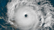
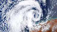
NARRATOR: Drawing power from ocean and air, it becomes a savage monster, nearly 300 miles across.
JEFF WEBER (University Corporation for Atmospheric Research): Winds of 195 miles per hour, gusts up to 240 miles per hour; right now, it's as big and as mean as a cyclone can, actually, probably get on this planet.
DR. DAVID ROBINSON (Rutgers University): This actually went off the scale. It was a monster storm.
NARRATOR: On November 8, 2013, it becomes what could be the most powerful typhoon in recorded history to make landfall.
PROFESSOR KERRY EMANUEL (Massachusetts Institute of Technology): This storm peaked right as it was going ashore at the Philippines. That's the tragedy.
NARRATOR: Haiyan brings terrifying winds, torrential rain and a deadly, high-speed flood.
JEFF WEBER: The 20-foot storm surge came almost instantaneously, like a tsunami. The devastation underneath this storm is unlike anything else we've seen underneath a tropical system before.
NARRATOR: In its terrible aftermath, thousands of lives, lost.
PAULO PARDILLA (Nurse): We did not expect that there will be a flood that will be coming.
GEORGINA BULASA (Resident): So many died because of the water, neighbors, families by families.
NARRATOR: Almost immediately, the questions begin.
FATHER HECTOR VILLAMIL (St. Joseph Parish, Tacloban City): Why so much, so much dead, so much casualty, with this typhoon? The media, the local media, even our own weather center, underestimated the surge.
NARRATOR: Could the deadly flood, the storm surge, have been predicted and catastrophe averted?
HAL NEEDHAM (Louisiana State University): We really have a long way to go with storm-surge modeling. We've come a long way, but we have a way to go.
NARRATOR: Is Haiyan a sign of things to come? The first of a new breed of super-typhoon?
MARSHALL SHEPHERD (University of Georgia): Are we loading the deck towards more intense storms in the future, as we provide a warmer base of ocean water for these storms to tap into?
NARRATOR: What could happen if the next killer storm strikes closer to home?
KERRY EMANUEL: If that storm had hit the southeastern U.S., it was so powerful that I think it would have been as much a disaster.
NARRATOR: The race is on to understand the Killer Typhoon, right now, on NOVA.
Typhoons: explosive storms that bring torrential rain, flooding and screaming winds. Typhoon is the term given to hurricanes that form in the northwestern Pacific Ocean.
MARSHALL SHEPHERD: Hurricanes and typhoons are some the most massive storms on the planet, and we see very strong typhoons in the western Pacific, more commonly than the people may think.
NARRATOR: Here, among the tropical islands north of Australia, are some of the warmest waters on the planet, fertile breeding ground for monster storms.
By late October, 2013, this region has already produced 14 typhoons. And now, unlucky number 15 begins to form, a killer whose name will soon become synonymous with devastation and heart-breaking loss: Haiyan. Eight days before it reaches land, Haiyan begins as what's called a tropical depression, a system of thunderstorms with winds less than 30 miles an hour, near Micronesia. In Hawaii, the Navy and Air Force's Joint Typhoon Warning Center monitors Pacific storms to protect U.S. military and government assets.LIEUTENANT THOMAS MILLS (Joint Typhoon Warning Center): We first noticed a weak disturbance southeast of Pohnpei Island, which is in the Micronesian Islands, the eastern most quadrant of the Micronesian Islands, on November 1st. We kept tracking there, until we kind of saw a broad general circulation.
NARRATOR: Tropical storms form over water 80 degrees Fahrenheit or warmer. The heat drives evaporation, and as the rising vapor cools, it forms clouds, releasing energy as wind and rain. The warmer the water, the more energy available to power the storm.
ASHLEY EVANS: We knew we had a pretty rich set of ingredients, because we had warm ocean temperatures underneath it, and it was pretty good circulation that it built up, so now this was going to get pretty big.
NARRATOR: Over the next 24 hours, the storm system continues to grow in size and strength. The rotation of the earth causes the strengthening system to spin counter-clockwise in the northern hemisphere. When wind speeds top 25 knots, about 30 miles per hour, the center issues its first alert.
THOMAS MILLS: Our first warning went out on November 3rd, at 1:00 a.m., Eastern Standard Time. At that point, our model fields extended out to five days, but five days out there was a lot of uncertainty.
NARRATOR: Very early on, the computers predicted that Haiyan would continue tracking over a layer of unusually thick warm water: 86 degrees to a depth of 300 feet, more than enough fuel to fan the flames of a strong storm, but just how strong, no one could yet know.
THOMAS MILLS: In the forecasting community, intensity is the difficult thing to forecast. We knew it was going to be a strong storm. We didn't know exactly how strong, but we knew it was going to be big one.
NARRATOR: On November 4th, 36 hours after the first warning, Haiyan becomes a typhoon, now with sustained wind speeds of more than 65 knots, about 75 miles an hour. And it is growing stronger with alarming speed.
THOMAS MILLS: At that point, it was just south of Guam. Within the next 24 hours after that, it intensified to 65 knots, so it doubled the intensity. And at that point, we are tracking it at 130 knots. One hundred thirty knots is considered a super-typhoon.
NARRATOR: A super-typhoon with sustained wind speeds above a hundred-and-fifty miles an hour, as destructive as the most notorious killer hurricanes, like Katrina that hit New Orleans in 2005; Andrew, that hit Florida with a 17-foot storm surge in 1992; and even Camille, in 1969, with wind speeds near 200 miles an hour at landfall.
And with every passing minute, Haiyan continues to grow in size and power and looks likely to slam into one of the region's most vulnerable targets: the Philippines. More than 7,000 islands, 120,000 square miles of land—about the size of Italy, but with nearly double the number of people—and a population density 10 times that of the U.S., it's considered a newly industrialized country with a growing economy, but millions of people still live precariously, while facing a multitude of natural threats.PROFESSOR KATHLEEN TEIRNEY (University of Colorado): The Philippines is subject to a variety of different natural hazards including volcanoes, typhoons, earthquakes, flooding, landslides, but, at the same time, it is a socially vulnerable place with many, many people living in extreme poverty.
NARRATOR: The millions of Filipino people living in coastal communities are accustomed to occasional typhoons, even super-typhoons. In the days leading up to landfall, most residents are taking the storm's approach in stride.
HECTOR VILLAMIL: It was not an alarming thing for us. We been used to typhoon, so it was not something extraordinary to be worried about.
SUSAN TAN (Store Manager): Everything was just so normal. I mean day-to-day operation of the grocery, people buying, but not in panic.
NARRATOR: But Haiyan is already far stronger than most typhoons, thanks to near ideal atmospheric conditions. In a strengthening typhoon, warm air rises through the eye, like smoke up a chimney. Crosswinds called wind shear can disrupt or block that flow, weakening the storm, but in the vicinity of Haiyan, wind shear is low. Additionally, the column of rising air benefits from winds in the upper atmosphere.
ASHLEY EVANS: In the upper levels, you need to have outflow from the storm, and that's, basically, wind in a position that's going to carry the energy that comes up through the atmosphere away from the center of the storm.
NARRATOR: The high-altitude winds create a suction effect at the top of the storm, drawing even more warm air in at the bottom of the column, feeding the storm like a roaring blaze in a well-ventilated fireplace.
ASHLEY EVANS: I'm drawing lots of moisture, lots of air, hot energy up into the chimney. I've got all the ingredients down at the bottom: I'm going to grow a nice hot, warm crackling fire.
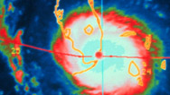
NARRATOR: As the storm reaches its peak intensity, the atmospheric pressure in the eye drops, possibly to one of the lowest levels ever observed, on par with the previous record, which was set 35 years ago.
MARSHALL SHEPHERD: The lowest recorded atmospheric pressure ever on the planet was recorded in a super-typhoon, super-typhoon Tip, from 1979. Early on with Typhoon Haiyan, many of us suspected that it could rival Tip in terms of its strength, just based on the structure and the intensity that we saw from various satellite datasets.
NARRATOR: Low pressure is an indication of how rapidly air is moving up through the eye. Looking down at the top of the storm, satellite images also reveal that there is heavy outflow at high altitude, not one, but two streams of warm air.
THOMAS MILLS: We were able to identify what we call "dual channel outflow." That means you have an enhanced outflow situation, which just allows that system to breathe better, vents better, allows it to grow and intensify even more.
NARRATOR: And there was yet another sign of the storm's incredible power.
ASHLEY EVANS: In the western Pacific we use a technique, it's the called Dvorak method, and it's where you actually look at the cloud structure, the banding of a particular typhoon, and you create a Dvorak number.
NARRATOR: Dvorak numbers indicate wind speed. The highest number on the scale is eight, reserved for the most powerful storms on record.
THOMAS MILLS: On November 7th, at 7:00 a.m., our SAT Analyst looked back at me, and she said, "Sir, we are at 8.0/8.0." 8.0/8.0 on the Dvorak scale corresponds to 170 knots.
NARRATOR: 170 knots, 195 miles an hour.
DAVID ROBINSON: This is a visible satellite image of the storm at its strongest point, and you can look right down in the eye and see the ocean waters below. The strongest winds, this is a daytime image, are right round the eye wall. This storm is reaching its peak strength at this time. This is just an incredibly powerful storm.
NARRATOR: On the afternoon of November 7th, the Philippine weather service upgrades their typhoon warning to Storm Signal 4, the highest possible. But for those on the ground, in harm's way, there is still little tangible sign of what is about to hit.
GIGI: There was only a few rains, and even when we were already signal number four, very fine weather, so, we were, me, I was so surprised, I was even telling myself and my kids it's okay to have signal number four.
NARRATOR: Finally, those living along the coast begin to take note, but preparations are far from adequate.
GIGI: We started to pack our things. We buy plastic cellophane, plastic, put our books, our TV, we covered it in cellophane.
NARRATOR: Haiyan is now almost 300 miles across. Forecasters around the world are watching intently, looking hopefully for some sign that it might weaken.
KERRY EMANUEL: As Haiyan approached land, forecasters got better data from satellites, and it became very clear this is a storm of unusual intensity we were looking at, a potentially catastrophic storm.
NARRATOR: One reason for alarm: Haiyan is unusually consistent. It intensified very rapidly and is now maintaining that intensity.
MARSHALL SHEPHERD: Typically, tropical cyclones—typhoon or hurricane—go through an ebb and flow cycle, in terms of if its intensity, or even its track, to some degree. One of the best examples that I can think of is Hurricane Katrina. As it was making its way through the Gulf of Mexico, it blossomed into a Category 5 storm relatively quickly, and that was because it moved over a pool of warm water called the Loop Current. After it moved off of that Loop Current, intensity went down some. Typhoon Haiyan maintained a relatively consistent track and a relatively consistent intensity as it was traversing the warm Pacific Ocean.
NARRATOR: With ample warm water, and undisturbed by wind shear, Haiyan shows no sign of weakening.
MARSHALL SHEPHERD: It was a strong storm, it remained a strong storm, and it made landfall as a strong storm.
JEFF WEBER: Right now, it's as big and mean as a cyclone can actually probably get on this planet: winds of 195 miles per hour, gusts up to 240.
KERRY EMANUEL: This storm peaked right as it was going ashore at the Philippines. That's the tragedy.
THOMAS MILLS: Just knowing that lives were going to be lost, infrastructure was going to be destroyed, it's gut-wrenching. And so I told my wife, "People are going to die on this one."
NARRATOR: Finally, at 4:40 a.m., local time, on the morning of November 8th, Typhoon Haiyan hits the east coast of the Philippines and unleashes a nightmare. Most homes and buildings simply cannot withstand such intense 200-mile-an-hour winds.
SUSAN TAN: Roofs flying, and somethingâ¦unbelievable things, motorbikes flying and even air conditioning units.
GEORGINA BULASA: Our house was already shaking, as if the wind was going to uproot the house.
NARRATOR: Residents take shelter in a local church.
HECTOR VILLAMIL: I saw the windows already gone. Coming in through the window, already gone, wind coming inside, all with a mist, white all white: "Woo, woo, woo."
DAVID ROBINSON: The wind speeds themselves were as if you had a moderate to strong tornado coming through. Tornadoes pass over in a minute or two, but these winds are blowing for an hour or two in some locations.
NARRATOR: The wind shreds countless homes.
CARMELITA BANTILAN (Resident): The roof was blown away. I was so scared, praying to the heavens saying, "Please stop this rain." At 5 a.m. our house was destroyed.
NARRATOR: Families find themselves exposed to the full fury of the elements, improvising ways to protect themselves.
CARLITO ARIAS (Resident): This was where he we hid after our house collapsed. We stayed right here. I crouched over all of them. I called their names. I said "Sarah, take care of Precious," her baby. Over here was Kristel and Laiza, there was Jamaica, Marife, Aaron and Angel. I huddled them together.
DAVID ROBINSON: This actually went off the scale. It was a monster storm, a textbook example of a classically strong super-typhoon. This was a terrifying storm.
NARRATOR: The city of Tacloban, on Leyte Island, home to 200,000, takes the full force of the storm. Almost immediately, the local hospital is threatened. The medical staff scrambles to move patients away from windows and exterior walls.
PAULO PARDILLA: We asked our patients to get out of their rooms and to slowly be on the basement or first floor. We thought that at that time it was safe for us. We place our patients here, only with their I.V., intravenous fluids. So, here, they pile up here.
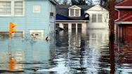
NARRATOR: Normally, seeking shelter on a low floor offers protection from the wind and rain, but now there's a new and far deadlier threat: storm surge.
MARSHALL SHEPHERD: Storm surge is one of the most hazardous aspects of any typhoon or hurricane.
JEFF WEBER: This storm is so intense, it had been developed for so long across the ocean, that it had in incredible amount of water behind it. As this was coming onshore the storm surge was as high as 20 feet.
NARRATOR: A storm surge begins when wind pushes water across the surface of the ocean. That displacement pulls more water upward from below. If the storm maintains its strength, the continuing churn sets up a vertical circulation, an underwater wave. The warmer the water, the larger the storm; the faster the winds, the bigger the wave. As it approaches land and the water becomes shallower, the wave bulges upward, causing sea level to rise.
The incredible intensity of Haiyan drives a huge storm surge, which is now crashing over the coastline. It's unlike anything the people here have experienced in the past. With water now just seconds away from the hospital, the decision to move patients lower in the building has put them all in grave danger.PAULO PARDILLA: The first water was up to here, only clear water. Then, after that, we see the surge, blackish water. And the surge and the wind and the flood was up to here, blackish water was up to here. So we try to assist our patients and get to the second floor to get up so we will be safe.
NARRATOR: At the local church, the wind has destroyed the roof, so when the surge pours into the ground floor, there's nowhere to hide.
HECTOR VILLAMIL: I said, "Okay, I cannot go up and take refuge, but I cannot go down anymore, because the water was rising up here." So, that's the thing. It's either the water or the wind. It's almost like "the devil or the deep blue sea."
NARRATOR: Almost every typhoon brings some flooding, but this typhoon is something else entirely. In minutes, the storm surge ravages the coastline sweeping away weak buildings, bringing floodwaters 20 feet deep.
One reason for the extreme height of the surge is Tacloban's location. The city happens to sit inside a relatively shallow, protected bay. As the surge approaches, the shallow offshore terrain pushes the water up. And at the same time, the narrow confines of the bay squeeze the water, causing it to rise even further.HAL NEEDHAM: In a storm surge event, strong onshore winds can really funnel water into these bays, so it's a little bit counterintuitive: these areas that tend to be the safest for cities or marinas, in a storm surge event, often are the most dangerous.
NARRATOR: The height of the surge brings horrendous flooding and destruction, but there's another reason that the surge is so deadly.
JEFF WEBER: The exceptional thing about this storm surge, with super-typhoon Haiyan, was the speed at which it came into some of these areas, like around the city of Tacloban.
JEFF WEBER: Storms surges generally come in increments, a foot, a foot or two, a meter at a time.
NARRATOR: One recent example of a gradual surge: Hurricane Sandy, the powerful storm that pushed up to 14 feet of water onto New York and New Jersey over more than 24 hours, but Haiyan's storm surge arrives in just minutes.
JEFF WEBER: Video from this storm shows the 20-foot storm surge came almost instantaneously, like a tsunami, and so the devastation underneath the storm is unlike anything else we have ever seen in a tropical storm system on this planet before.
NARRATOR: For those near the coast, there is no escape. And for those whose houses have been destroyed, the rushing water is deadly.
CARLITO ARIAS: Then the water came in. I told them, "Get up! Up! Water!" And just like that the water rose up to my chest. It was not a normal flood from rainwater, but a wave coming in from the shore. It was so sudden. It was at my ankles, then suddenly up to my chest. And the next wave brought the water up to my neck, until I was completely submerged. My child held on to my shoulder to keep me near.
NARRATOR: It is rapidly shifting winds offshore that are causing the surge to come in with the speed of a tsunami. As the rotating storm approaches, the first winds to strike the bay come from north of the eye, blowing north to south. That powerful force initially shoves water away from the city.
The winds were actually blowing offshore, and that was keeping the water away or even producing what we call a negative storm surge, where sometimes water is actually pushed out of the bay.NARRATOR: Then, as the storm passes, winds coming from south of the eye, blowing in the opposite direction come into play. Water rushes back into the bay, pushed powerfully forward by the reversing winds. And that's what produced the sudden dangerous and deadly storm surge.
The city of Tacloban is inundated. At the hospital, the staff uses floating mattresses to rescue the old and infirm.PAULO PARDILLA: This was, is the level of the water. Up to here, the patient was floating. We slowly assist the patient in his hospital bed. There is a gushing of wind; there is a strong current of the water. The other patients were terrified, were in panic, and we assist the patients to be in that bed. The bed was to slowly carry the patient up to here, so we can have rescue here.
GEORGINA BULASA: The water came so sudden. My children were crying. They were all, they were in panic. Everything floated like a paper, the refrigerator, the divider, and the flat screen TV and everything. It floated like a paper.
NARRATOR: They had steeled themselves for high winds and torrential rain, but there was no way they could have foreseen this huge wave of fast-moving water, so unlike anything anyone living here had ever experienced.
HECTOR VILLAMIL: We never consider the storm surge and the destruction that it would bring us.
DAVID ROBINSON: It was a combination of the incredibly strong winds and massive storm surge, and if you were in harm's way, you may have lost your life. If you didn't lose your life, I guarantee you were terrified for several hours, as this storm came across your area.
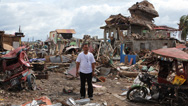
NARRATOR: Twenty hours after it makes landfall, Haiyan clears the Philippines. Great swaths of the 7,000-plus islands that make up the Philippine archipelago are devastated, leaving this: an apocalyptic landscape, an unimaginable toll in human lives and property; at least 6,000 dead, 1,800 missing and around 4,000,000 people homeless. In the immediate aftermath, survivors struggle to understand why this storm brought so much suffering.
HECTOR VILLAMIL: Why so much, so much dead, so much casualty, with this typhoon? The media, the local media, even our own weather center underestimated the surge. They were only monitoring the direction of this typhoon, the speed and the strength, but never mentioning about the surge.
EDGAR TABUYAN (Resident): That's one of the reasons they were confident, they were staying at home, because they do not know what is a storm surge.
HECTOR VILLAMIL: And they could have evacuated. Mandatory evacuation for all the people living in the sea line, one or two kilometers inland. But the thing, it didn't happen. So they said that during the typhoon, they were actually here, they did not evacuate, they were here. There were three families inside, and when the surge came in it destroyed the house and split them up. And in the process they lost a lot of their family members: the motherâ¦
MOTHER: The mother, my three children and two children of my sister.
NARRATOR: The Philippine weather service did predict a large storm surge, but no one expected that it would come so quickly into places like Tacloban. Part of the challenge is in the difficulty of predicting just how intense a typhoon will be at the moment when it reaches land.
HAL NEEDHAM: That becomes a little bit difficult, because you have a lot of complex things happening. How will these different ingredients, like the track of the storm, the wind speed, how will all of these things really affect the water height?
We really have a long way to go with storm-surge modeling. We've come a long way, but we have a long way to go.NARRATOR: Surge models depend not only on the coastal geography, but also on wind speed and direction at landfall. In a powerful typhoon, those variables can change rapidly, making the kind of precise prediction that might have saved Tacloban extremely difficult, if not impossible.
HAL NEEDHAM: Tacloban, which was devastated from Typhoon Haiyan, if you shift that track a little bit, in the next storm, they might not get a storm surge at all.
NARRATOR: Even without the surge, such a sustained bombardment was bound to bring death and destruction. But there were also signs that life is very resilient. Across the islands, many new babies weren't willing to wait for the storm to pass.
CARMELITA BANTILAN: My husband shouted out, "The baby's here! It's born!" We were just thankful that we survived.
NARRATOR: In the immediate aftermath of Haiyan, many survivors have no water, food or shelter. Some places are so remote that essential help is slow to arrive.
When some airports open a day later, aid begins to arrive for the victims of Typhoon Haiyan. Cargo planes ferry high-energy biscuits, rice, water and other supplies from the U.S.TOWER CONTROLLER: Hey, Walter, come here. That staff sergeant, right there, tell him we need a lot of manpower to get that C-130 offloaded as soon as possible. We're going to get some marines, as well.
NARRATOR: The American military deploys a strike group from Hong Kong and Japan: nine ships, 23 helicopters and 7,000 personnel, to distribute 300 tons of aid to storm-ravaged islands.
LIEUTENANT COMMANDER DAMON LOVELESS (U.S.S. George Washington Strike Group): So, this is a helicopter, landing. It's one of the helicopters of the strike group. And we're getting ready to load up people and supplies. We are bringing food, water supplies, shelter and medicine to everyone that we can get supplies to, and right after that, we're trying to get the most urgent need, typically people that are isolated on smaller islands that can only be accessed by boats or helicopter.
NARRATOR: In the first few days, military experience proves invaluable.
DAMON LOVELESS: It's quite busy, but it's actually something that the military is actually quite good at. And I'm just a liaison, but I can tell you the Marine Corps logistics specialists, the Army and the U.S. Air Force, they are all magicians when it comes to that. And I'm glad we have them on our side. They makes stuff happen and keep supplies at the front, and, in this case, the front is disaster relief.
DR. IRWIN REDLENER (National Center for Disaster Preparedness, Columbia University): In the immediate phase after a storm like this, we're trying to do two things: we're trying to rescue people who are in life-threatening situations, and we're trying to provide them care to save their lives. And then, the second phase is to keep people safe and alive who survived the initial impact, because, after about 72 hours, after about three days, people who survived but now need things like clean water, antibiotics, shelter and didn't get it are not surviving.
NARRATOR: The military response is critical. Equipped to move quickly and able to reach inaccessible places, they are the first to arrive. But after a few days, the job falls to non-governmental agencies and other specialists, who are already laying the groundwork for a longer-term effort.
CAT CARTER (Save the Children): So far, this has been very effective. From what I have seen, this has been one of the most effective responses, actually. I had some real struggles getting aid in at the start, because of the logistical challenge. The airport was destroyed, the command center was destroyed, no electricity, the roads were clogged with debris and dead bodies, so, huge logistical challenges. But now that's up and running, now that we've got a way in, we can see the aid effort just multiplying over the next couple of days.
NARRATOR: As the slow and difficult process of rebuilding gets under way, questions are again being asked about whether this latest killer storm is linked to climate change.
Greenhouse gases, like carbon dioxide, generated by burning fossil fuels, are building up in our atmosphere, insulating our planet, holding in more of the sun's heat and driving the temperature up. What role do those rising temperatures play in the intensity of storms?JEFF WEBER: Typhoon Haiyan was not caused by global warming. Global warming or a warmer environment could have exacerbated Typhoon Haiyan. Typhoon Haiyan was going to happen because it had the energy and it had the atmospheric conditions ready for it to develop.
IRWIN REDLENER: Some scientists feel that it may not have a consequence in terms of the frequency of these storms, but it may have a big consequence in terms of the intensity of these storms.
KERRY EMANUEL: One of the great myths of climate change is that it is controversial among scientists. It is not. Ninety-seven percent of all scientists who actually work on climate agree. The only sensible approach is to regard this as a problem of risk. There will never be certainty. If we are very, very lucky, maybe nothing of much importance will happen; if we are very unlucky, it will be catastrophic.
We think there is a relationship between incidents of intense storms and climate change, but we don't actually expect to be able to see that in real data, perhaps for another few decades.MARSHALL SHEPHERD: The way I like to frame that is in terms of steroid use in baseball. I can't tell you specifically which homerun a Major League baseball player hit was caused by steroid use. But in the average, we know that during the steroid era there were homeruns and there were longer homeruns. And so that's kind of how I frame the discussion about climate change and hurricanes: any specific typhoon, like a Haiyan, can happen in a given year. Are we loading the deck or loading the dice towards more intense storms in the future, as we provide a warmer base of ocean water for these storms to tap into?
NARRATOR: Warmer oceans cause water volume to expand. At the same time, glaciers are melting. The result: sea level around the world is rising.
JEFF WEBER: A rising sea level makes these storms far more dangerous, because it puts that many more people at risk with the storm surge.
KERRY EMANUEL: What's not so commonly known about sea level rises is that it is not globally uniform. The Philippines is one of the parts of the world where we have seen, in the past 20 or 30 years, the most rapid rise in sea level. I think, in the past 30 years, it was about eight inches or so higher than it was before.
DAVID ROBINSON: It's not going to take as powerful a storm surge to create the damage we saw from Haiyan, if sea level is one or two feet higher 50 years from now. So, the vulnerability of our coastal communities that are traditionally, or historically, in the path of these storms is only going to get worse, just from sea level rising, let alone the fact that we may have more of these storms or more powerful storms.
NARRATOR: Haiyan's storm surge was a function of the strength and direction of its winds, as well as the shape of the coastline and the underwater terrain, conditions not unique to the Philippines.
KERRY EMANUEL: We might be tempted to think, in the developed world, you know, if that same storm had hit America or Britain the consequences would have been a lot less. I don't think so. If that storm had hit the southeastern U.S., it was so powerful that I think it would have been as much a disaster, economically a lot more of a disaster, just because there's so much more stuff there.
NARRATOR: One densely settled area in the U.S. that might be particularly vulnerable to a lethal storm surge is on the west coast of Florida: Tampa and St. Petersburg, home to almost 3,000,000 people.
This area has all the factors that could produce a really devastating storm surge: they have a bay there that can really funnel water into that area; they are in the subtropics there, so they can receive strikes from hurricanes and tropical cyclones.
Many hurricanes that hit Florida travel east to west, across the peninsula. But in 1848, two hurricanes made landfall north of Tampa, traveling northeast, pushing a large surge towards land. Some storm-surge modelers have said that you can get a storm surge exceeding 20 feet in the Tampa Bay Area. Because no one alive has experienced that type of hurricane, few in harm's way are prepared for its effects.HAL NEEDHAM: If you drive around the Tampa area, if you look at the flood defenses, you will often see huge subdivisions with very expensive homes right up to the waterfront, with maybe a two- or three-foot seawall. Easily, in a major storm surge, those homes which would just be completely washed away. You need a very specific track to funnel water into that bay. It doesn't happen too frequently, but it has happened before, and it will probably happen again.
NARRATOR: And that's just one community that may be vulnerable. In an era of rising sea levels, hundreds of millions of people around the world may be affected by coastal flooding.
The aftermath in the Philippines makes plain the stakes for any vulnerable coastal community threatened with a Category 5 hurricane or super-typhoon. Haiyan has created one of the worst resettlement crises in recent memory. Around 4,000,000 people have been displaced, more than twice the number made homeless by the deadly tsunami that struck Indonesia in 2004. In the hardest hit towns, the relief effort will need to continue for years. Even those who have witnessed other catastrophes have difficulty coming to terms with the extent of the loss.CAT CARTER: I came down, walking, just a few days after I arrived, and I looked over the ocean, and I remember seeing a boat out on the sea and thinking that you know, "Oh, that's great. They're fishing again. It's a sign of resilience. Look how quickly they've got past this disaster." And it took a while, I think, for my brain to catch up with what my eyes were seeing, and I realized that they weren't fishing, they were pulling dead bodies from the water. And all along the beach, they'd lined up dead bodies, and lots of them were children. And that was kind of the moment, for me, that the enormity of what had happened came crashing down around me.
NARRATOR: In the town, sick and injured people flooded into Bethany Hospital. Nurse Paulo Pardilla worked tirelessly to save lives, but he had no idea if his own family was dead or alive.
PAULO PARDILLA: I had no communication with them, because the cellular phones, the link of communication was shut down. But I was just praying that my family was safe.
NARRATOR: Paulo spent 24 hours helping in the hospital, then he walked to his home in a village on the outskirts of the city. There was no transport. Everything was in ruins. He had no idea what he would find. It took him a day, but, to his relief, his mother and family were all alive.
GILMA PARDILLA: First time in my life, this is the strongest storm I ever experienced.
NARRATOR: Paulo's brother's family, next door, all survived, but their house did not.
PAULO PARDILLO: It was the fruit tree. A big branch of that was able to fall on the, on the house of my brother.
PATRICK PARDILLA: So, my daughter was so scared, so we ran out and go to my mother's house.
NARRATOR: The concrete walls of Paulo's mother's house withstood the fierce winds of Haiyan, but they were no protection against the storm surge. Floodwaters rushed through the house, and for eight hours the family huddled together on the steps.
GILMA PARDILLA: We sit down here, my granddaughter, my daughter-in-law, here, my husband standing, holding the ceiling, because it might fall to us. We just keep on praying the lord may save us.
NARRATOR: Paulo's family were some of the lucky ones. But when the typhoon had passed, the city of Tacloban was a disaster zone. Whole neighborhoods were left barely recognizable.
HECTOR VILLAMIL: You cannot see many of the houses there, because it's covered with foliage, like trees and leaves, but now you can see even that mountain at the end. Now it's all gone.
IRWIN REDLENER: In many developing countries, there is no choice. If you want to support your family and yourself, you have to live near the coast. You are forced to remain in place, even in these high-hazard zones.
NARRATOR: Many survivors are haunted by memories of what they endured during the storm. With his home blown away, Carlito Arias found himself desperately holding on to his children as the sea surge came rushing in.
CARLITO ARIAS: My child held on to me, but the next wave took me far away from them. That was the most painful part, I couldn't protect them any longer.
NARRATOR: Once the storm passed, Carlito searched for the children and relatives he tried to protect. One by one, he found their bodies. He was then left with the task of building a grave for those he lost.
CARLITO ARIAS: I told the family the news, that we didn't have a choice but to bury them ourselves. So we wrapped them well in hand-woven mats.
NARRATOR: The burial was swift. No time for the usual embalming and coffins. They were laid to rest, all together, in a sacred place.
CARLITO ARIAS: I want to cement it well, to show I haven't forgotten and still love them.
KERRY EMANUEL: I don't think anybody could have dealt with this typhoon, because it was so out of the normal range of intensities. Haiyan became as destructive as it did, because of a coincidence of very favorable circumstances. Haiyan had everything going for it, in some sense; the people of the Philippines had everything going against them in this event.
NARRATOR: Among the millions of people left without a roof over their heads are Georgina Bulasa and her husband.
GEORGINA BULASA: That is my husband, building a house, a very simple one. He is just using whatever is usable now. Besides, we do not have the money to buy materials, and there is no store open, so me and my husband are hoping that, in due time, we will be able to start anew, again.
NARRATOR: Nurse Paulo Pardilla is back to helping those affected by the typhoon. With Tacloban's hospital flooded, relief workers have set up a temporary medical center.
PAULO PARDILLA: What's new in the last two days, for us, is a feeling of joy and hope, especially for us nurses, as we can continue our work. Today, our hospital is not yet opening or not yet in service. The tent hospital is a means for us to continue rendering care and service to the people, especially to those who have been affected by the typhoon.
NARRATOR: The Philippine government estimates the cost of reconstruction at around eight billion dollars. In the affected area, key industries such as agriculture and fishing have all but been destroyed. For the people on the ground, it would be easy to be overwhelmed, but the job now is to rebuild.
EDGAR TABUYAN: We don't have no plan to go elsewhere, but to stay here and rebuild whatever we can, because this is our home; no place like sweet home.
NARRATOR: The priority for Father Hector is his parish. This is a religious community, and, for many, the church is needed more than ever.
HECTOR VILLAMIL: We always have that strong spirit to rebuild in our own little way, in our own simple way. We don't have a roof over our heads, but the thing is, they will do their best to celebrate that Mass, and I believe they would be coming in to be grateful to God for their lives.
CARMELITA BANTILAN: What are we going to do? Even money to buy little things, we don't have any. So what are we going to do?
GEORGINA BULASA: We hoping that big hope, that, slowly, we're going to make it back to normal again.
HECTOR VILLAMIL: It's a tradition for Filipinos that they never give up, even in spite of all this disaster. In spite of all the tragedies they won't give up. We lost a lot of lives, and that's a fact that we have to accept and to live with. It will take some times. It's part of our culture that in spite of all the pains and suffering that we have endured, they're still smiling.
Broadcast Credits
- PRODUCED AND EDITED FOR NOVA BY
- Dan McCabe
- EXECUTIVE PRODUCER
- Chris Schmidt
- PRODUCED AND DIRECTED FOR SKY VISION BY
- Dick Bower
- EDITORS
- Brian Truglio
Vincent Liota
Jason Porterhouse
Zilke Lemmer
Dave Monk
Daniel Garcia Robles - CAMERA
- Steve Nettleton
Paul Woodd-Walker
Richie Mockler
Mostyn Pryce
Richie Vale
Jay Schexnyder
Stanford Chang - NARRATED BY
- Craig Sechler
- ASSOCIATE PRODUCER
- Will Toubman
- EDIT PRODUCERS
- Cassie Farrell
Ben Summers - FIELD DIRECTORS
- Nathan Harrison
Nick Hardie - STORY PRODUCER
- Nonuk Walter
- ADDITIONAL PRODUCING
- Kate Tobin
Robin Lung - ADDITIONAL EDITING
- Doug Quade
Lauren McGuiness - FIXER
- Inky Santiago-Nakpil
- VOICEOVER TRANSLATION
- Leonore Getchell
Leon Getchell - MUSIC
- ScoreKeeper's Music
Extreme Music
Audio Networks - ANIMATION
- Sputnik Animation
Simon Godfrey - ASSISTANT EDITOR
- Jim Fetela
- ONLINE EDITOR
- Michael H. Amundson
- COLORISTS
- Michael H. Amundson
Trevor Brown - AUDIO MIX
- John Jenkins
- ARCHIVE PRODUCER
- Susannah Owen
- ASSOCIATE RESEARCHER
- Shraddha Chakradhar
- ARCHIVAL MATERIAL
- ABS-CBN
AP Archive
Barcroft Media
Corbis Images
Earth Uncut Productions
Jim Edds
Eric Feijten
Framepool
Getty Images
GMA Network
ITN Source
JMA/EUMETSAT
NASA
NASA/ISS/Karen Nyberg
Casey Neistat
Newsflare
NOAA
Jake Perez
Plan International
Pond5
Jeff Schmaltz, LANCE/EOSDIS
Shutterstock
UCAR
US Dept. of Civil Defense
Videoplugger
Yonhap News Agency
James Reynolds - SPECIAL THANKS
- Deltares
Space Science and Engineering Center, University of Wisconsin-Madison
Dr. David Titley - EXECUTIVE PRODUCERS FOR SKY VISION
- Kathy Hale
Danny Tipping - PRODUCTION MANAGER FOR SKY VISION
- Peter Guest
- PRODUCTION COORDINATOR FOR SKY VISION
- Vicki Lindsay
- NOVA SERIES GRAPHICS
- yU + co.
- NOVA THEME MUSIC
- Walter Werzowa
John Luker
Musikvergnuegen, Inc. - ADDITIONAL NOVA THEME MUSIC
- Ray Loring
Rob Morsberger - CLOSED CAPTIONING
- The Caption Center
- DIRECTOR OF PUBLIC RELATIONS
- Jennifer Welsh
- PUBLICITY
- Eileen Campion
Eddie Ward - SENIOR RESEARCHER
- Kate Becker
- NOVA ADMINISTRATOR
- Kristen Sommerhalter
- PRODUCTION COORDINATOR
- Linda Callahan
- PARALEGAL
- Sarah Erlandson
- TALENT RELATIONS
- Scott Kardel, Esq.
Janice Flood - LEGAL COUNSEL
- Susan Rosen
- DIRECTOR OF EDUCATION
- Rachel Connolly
- DIGITAL MANAGING PRODUCER
- Kristine Allington
- SENIOR DIGITAL EDITOR
- Tim De Chant
- DIRECTOR OF NEW MEDIA
- Lauren Aguirre
- DEVELOPMENT ASSOCIATE
- Lisa Leombruni
- UNIT MANAGER
- Ariam McCrary
- POST PRODUCTION ASSISTANT
- Brittany Flynn
- POST PRODUCTION EDITOR
- Rebecca Nieto
- POST PRODUCTION MANAGER
- Nathan Gunner
- COMPLIANCE MANAGER
- Linzy Emery
- BUSINESS MANAGER
- Elizabeth Benjes
- DEVELOPMENT PRODUCER
- David Condon
- PROJECT DIRECTOR
- Pamela Rosenstein
- COORDINATING PRODUCER
- Laurie Cahalane
- SENIOR SCIENCE EDITOR
- Evan Hadingham
- SENIOR PRODUCER
- Julia Cort
- SENIOR SERIES PRODUCER
- Melanie Wallace
- MANAGING DIRECTOR
- Alan Ritsko
- SENIOR EXECUTIVE PRODUCER
- Paula S. Apsell
A NOVA Production by SKY VISION for WGBH in association with SKY NEWS
© 2014 Sky Vision and WGBH Educational Foundation. All rights reserved.
Additional Material © 2014 WGBH Educational Foundation
This program was produced by WGBH, which is solely responsible for its content.
IMAGE
- Image credit: (Quiuan, Phillipines after Typhoon Haiyan)
- © Bryan Denton/Corbis
Participants
- Carlito Arias
- Resident
- Carmelita Bantilan
- Resident
- Georgina Bulasa
- Resident
- Cat Carter
- Save the Children
- Kerry Emanuel
- Massachusetts Institute of Technology
- Capt. Ashley Evans
- Lt. Cdr. Damon Loveless
- USS George Washington Strike Group
- L.T. Thomas Mills
- Joint Typhoon Warning Center
- Hal Needham
- Louisiana State University
- Gilma Pardilla
- Resident (Paulo's Mother)
- Paulo Pardilla
- Nurse
- Irwin Redlener
- Columbia University
- David Robinson
- Colgate University
- Marshall Shepherd
- University of Georgia
- Edgar Tabuyan
- Resident
- Susan Tan
- Store Manager
- Kathleen Teirney
- National Hazards Center, University of Colorado
- Father Hector Villamil
- St. Joseph Parish, Tacloban City
- Jeff Weber
- University Corporation for Atmospheric Research
Preview | 00:45
Full Program | 52:52
Full program available for streaming through
Watch Online
Full program available
Soon
Related Links
-

Recovering From Typhoon Haiyan
After the disaster, recovery in the Philippines will involve more than just distributing food and water.
-

Anatomy of a Super Typhoon
Changing climate patterns turned Haiyan into one of the most devastating storms in the Philippines's history.
-

Crowdsourcing Climate Fixes
By collaborating online, people from around the world can devise and refine solutions and adaptations to climate change.
-
Haiyan's Displaced—...
Thousands of Filipinos made homeless by Typhoon Haiyan are ordered to relocate.
-

Better Forecasts with Drones
How tropical cyclones intensify remains a mystery, but unmanned aerial vehicles could fill critical gaps in the data.
-

Hurricanes and Climate Change
Why climate change is making hurricanes more dangerous.
-
Storm That Drowned a City
Experts and eyewitnesses reconstruct the devastating floods that Hurricane Katrina unleashed on New Orleans.
-

Forecast for the Floodplains
Urban development coupled with intense hurricanes is causing storm damage to ripple beyond the coastline.
-

Climate Change and Sandy
A climate scientist suggests that rapid warming in the Arctic helped create October's "superstorm."
-

Megastorm Aftermath
How can cities prepare for rising seas and raging storms?
-

Inside the Megastorm
Watch as Megastorm Sandy unfolds, and explore what made it so much more devastating than other hurricanes.
-

Hotter Oceans, Fiercer Storms
In this audio slide show, examine the link between rising sea surface temperature and more intense storms.
-

Hurricane Power
Your average hurricane releases enough energy to power the world 200 times over. Go figure.
-
The Coriolis Effect
Why do storms spin as they travel?
-
Quiz: Hurricanes
Five questions that will separate the hurricane know-it-alls from the rest of us
-
Hurricanes
Predicting a hurricane's intensity is difficult, but new tools may make it easier.
-

Storm Surges and New York City
How multiple lines of defense, from massive barriers to oyster reefs, can protect our cities from storm surges.
Additional funding for this program is provided by Millicent Bell, through the Millicent and Eugene Bell Foundation.


National corporate funding for NOVA is provided by Draper. Major funding for NOVA is provided by the David H. Koch Fund for Science, the Corporation for Public Broadcasting, and PBS viewers.