Mars From Afar
We're all armchair travelers when it comes to Mars, but
fortunately a number of spacecraft bearing sophisticated
cameras have orbited and even landed on the planet over the
past three decades. These spacecraft have provided a steady
stream of breathtaking images of the martian surface that, as
you'll see in this sampler, are the next best thing to being
there. To see the images to full effect, please click on each
image to enlarge it. You may also want to resize the resulting
popup window to fill the screen. Unless otherwise noted, all
images were taken by the Mars Global Surveyor's Mars Orbiter
Camera. For the latest news on the Spirit and
Opportunity rovers, see the website of the
Mars Exploration Rover Mission. For updates on the Phoenix lander, visit the
Phoenix Mars Mission
website. See also
Links & Books.—Peter Tyson


|
|
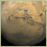
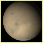
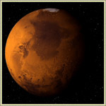
The Planet
This is Mars as it appeared in May 2002. It's early
spring in the Northern Hemisphere, whose seasonal
carbon-dioxide frost cap has begun its annual retreat.
Other white areas in this composite are clouds, some
seen hovering over volcanoes such as
Olympus Mons, the dark round spot in
the far left of the image. The huge canyon system known
as Valles Marineris is visible as a
thick horizontal line in the lower right. All told, Mars
is about 4,200 miles in diameter, a little over half as
big across as the Earth.
|
|
|
Canyon
In the center of this mosaic of Mars lies the Valles
Marineris, the largest known chasm in the solar system.
It stretches over 1,860 miles from west to east, and in
places reaches five miles in depth. (The Grand Canyon,
at its deepest, is just over a mile from rim to river.)
Huge rivers once flowed north from the chasm's
north-central canyons to a vast basin called Acidalia
Planitia (the dark area in the top right of the image).
To the west of the Valles Marineris you can see three
ancient volcanoes (dark brown circles), each about 15
miles high. This mosaic consists of 102 images from the
Viking Orbiter, and the viewer's distance is 1,550 miles
above the surface.
|
|
|
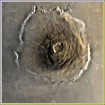
Volcano
This mosaic of images taken by Viking 1 on June 22,
1978, shows Olympus Mons, the highest known volcano in
the solar system. Its summit caldera lies over 78,500
feet above the surrounding plains, making it over two
and a half times the height of Mt. Everest. The volcano
proper, defined by the roughly circular cone visible in
the center of the image, is about 340 miles in diameter,
revealing just how gradual a slope the mountain's flanks
display. Encircling the volcano is a moat of lava
thought to have come from Olympus Mons.
|
|
|
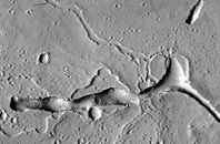
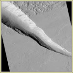
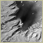
Volcanic Vent
This deep trough lies in the Tharsis region of Mars,
home to several of the largest shield volcanoes in the
solar system. It is a volcanic vent, where lava erupted
long ago. The shallow, scalloped depressions in the
middle and left (west) of the image may have been lava
lakes that emptied into the vent at the end of the
eruption that created the vent. To the right (east) are
two channels that once likely drained the vent. Once
deeper and narrower, the vent became more trough-like as
material eroded from its sides and fell to its floor.
The image was taken on December 6, 2006, by the High
Resolution Imaging Science Experiment.
|
|
|
Sand Dunes
Resembling a group of horseshoe crabs coming ashore,
windblown sand dunes grace the floor of Wirtz Crater.
The shape of the dunes indicates that the wind has blown
the sand from the southwest toward the northeast (lower
left to upper right in the image). Illuminated by
sunlight streaming in from the northwest, the scene
comprises an area less than two miles in width.
|
|
|
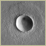
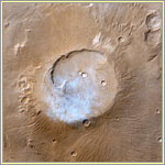
Crater
Looking like it might have been blasted out yesterday,
this impressive meteor impact crater lies in the
northern Elysium Planitia, the second largest volcanic
region on Mars. The crater's diameter is a little over
twice that of Meteor Crater in Arizona (which is three
quarters of a mile wide and our planet's best preserved
impact crater). Darkening more than half the crater, the
shadow gives an idea of just how deep the basin is.
|
|
|
Ice Cap
Dubbed martian "Swiss cheese," these raised sections of
ice in the south polar ice cap and the circular
depressions within them may be a combination of water
ice and frozen carbon dioxide, or "dry ice." The area
covered in this image is 1.9 by 5.6 miles, and the
tallest portions of the raised ice mesas are about 14
feet high.
|
|
|
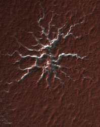
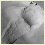
Polar Gas Channels
Known informally as a "spider," the topographic feature
seen in this image of Mars' south polar region
represents a process not found on Earth. The branching
tendrils contain carbon dioxide gas, which flows through
the channels until it reaches a vent; it then escapes to
the atmosphere, carrying dust with it. The tendrils,
appearing bright-white with the carbon dioxide ice that
covers the poles during winter, weave into the
surrounding icy terrain, which, in turn, is blanketed by
the region's characteristic reddish-brown dust. The
image was taken on March 24, 2007, by the High
Resolution Imaging Science Experiment.
|
|
|
Faulting
The deep trough slashing diagonally across the center of
this image resulted from faulting and down-dropping of
the land. Boulders the size of small buildings can be
seen on the slopes of this depression, which is sunlit
from the left. Dark streaks on the trough's slopes are
the paths of small landslides. This trough and the
shallower one in the lower part of the image cut across
lava flows, suggesting that the trenches formed after
the lava had cooled and hardened. Short, parallel ridges
in the valley floors are probably dunes.
|
|
|
Layered Rocks
Water or wind deposited the sediments that are thought
to make up these layered rock outcroppings. Wind later
shaped and exposed the layers, which on close inspection
resemble those on a topographical map. Note the dark
drifts of sand in the lower center of the image, which
is illuminated by sunlight coming from the upper left.
The scene is in the bottom of an impact crater near the
martian equator.
|
|
|
Gullies
Not dramatically different from a mountainside in, say,
the American Southwest, this weathered wall of a crater
displays gullies that might have been carved by
groundwater flowing downhill. Wintertime frost dusts the
wall, while below on the crater floor you can see dunes
sculpted by the wind. The Mars Global Surveyor's
narrow-angle camera took the shot, which was then
"colorized" using actual colors of the surface obtained
by the spacecraft's wide-angle cameras.
|
|
|
Clouds
One early martian afternoon in April 1999, the Mars
Orbiter Camera (MOC) captured this view of diaphanous
clouds floating over the summit of Apollinaris Patera, a
volcano near the planet's equator. The various impact
craters pockmarking its crater and flanks indicate how
ancient the volcano is. It is also enormous: An
estimated three miles high, its summit caldera alone is
about 50 miles across. The color in this image was
derived from the MOC's red and blue wide-angle camera
systems and does not represent true color as you would
see it with the naked eye.
|
|
|
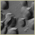
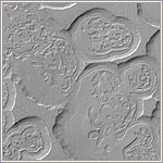
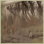
Mesas
To some viewers, the spaghetti-like forms captured in
this image may at first glance appear raised from the
surface, but they are actually troughs separating
layered mesas. Pitting and erosion fashioned the mesas,
which are lit by the sun from the lower left. Dust
cloaks the landscape, and large, wind-crafted ripples
can be seen on the trough floors. The image is slightly
less than two miles wide.
|
|
|
Landslide
Sometime in the distant past, a large portion of this
slope in the Kasei Valles region gave way and slid down
into the valley below. Scientists know it was a long
time ago because of the impact craters apparent in both
the landslide's scar and its resulting deposit. At the
base of the scar, just below the slightly oval-shaped
impact crater, you can see numerous black dots. These
are house-sized boulders that have tumbled down from
higher up the 660-foot slope. Near the cornice, you can
just make out layers in the bedrock revealed by the
landslide.
|
|
|
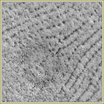
Plains
Like certain high-latitude areas in the Northern
Hemisphere on Earth, the northern plains of Mars often
show patterned ground. Whether this stippled surface
indicates ground ice, as similar-looking surfaces do in
parts of Alaska, Canada, and Siberia, is unknown. In
this image, taken at a latitude of 72.4°N, the dark
dots and lines are low mounds and chains of mounds,
respectively. Note the buried impact crater in the
center of the image, which is about 1.9 miles across.
|
|
|
Dust Storms
In late June 2001, as the martian southern winter gave
way to spring, dust storms began to kick up as cold air
from the south polar ice cap moved north toward warmer
air at the equator. By early July, dust storms had
cropped up all over the planet, whose surface, by the
end of the month, had become almost entirely obscured,
as if by a single, global storm. By late September, the
storms had largely abated, though the atmosphere
remained hazy into November.
|
|
|
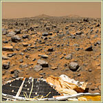
Terrain
Mars Pathfinder's stereo imaging system took a series of
photographs that were used to create this 360-degree
"geometrically improved, color-enhanced" panorama of the
surface of Mars. The images were made over the course of
three martian days to ensure consistent lighting and
shadows across the panorama. In the lower portion of the
image, you can see the lander, with its opened petals,
deflated airbags, and pair of ramps. The Sojourner rover
descended the rear (right) ramp to the surface, then
made its way to the large rock, dubbed "Yogi," where it
is using its Alpha Proton X-Ray Spectrometer to study
the rock's composition. The "Twin Peaks" visible on the
horizon are less than a mile and a quarter away.
|
|
|
Frozen Water
Use the slider (in enlarged version) to compare these
two color images from the Phoenix Mars Lander, which
touched down on the Red Planet on May 25, 2008. The
lander's Surface Stereo Imager took these pictures on
June 15 and June 19, respectively. The pictures show
sublimation—the passing of a substance, in this
case ice, directly from a solid to a gas—in a
lander-dug trench over the course of four days. In the
lower left of the lefthand image, a group of white lumps
is visible within the shadow; in the righthand image,
they're gone. Look closely also at the white patches in
full sun—other loss of ice can be seen there.
These images confirmed the presence of water ice in the
subsoil of the martian arctic.
|
|
|
The Planet, Again
This QuickTime VR, or full-round panorama, was created
from a photo-mosaic of images captured over a five-year
period by the Viking orbiters in the 1970s. The smooth
areas of the globe are geologically younger than the
cratered areas, which are ancient. In places, cliffs of
up to a mile and a quarter in height separate the two
areas. Some Mars experts speculate that water may have
once covered the Northern Hemisphere, which is smoother
and younger than the Southern. Note bright and dark
streaks on the martian surface; these point to active
wind processes on Mars.
1.3MB; requires free
QuickTime
plugin software
|
|
|