Explore the Scablands
- By Peter Tyson
- Posted 09.20.05
- NOVA
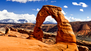
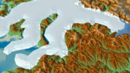
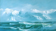
"It was the biggest flood in the world for which there is geological evidence," writes Norman Maclean in A River Runs Through It, referring to the catastrophic deluge that tore through the Pacific Northwest every time Glacial Lake Missoula's ice dam gave way. "[I]t was so vast a geological event that the mind of man could only conceive of it but could not prove it until photographs could be taken from Earth satellites." Proof now in hand, geologists today point to numerous features in the landscape that reveal the extreme scale and violence involved in these truly colossal floods. In this interactive map of the vast region affected, both within the storied Channeled Scabland and beyond, take a look at some of these telling features.
 Launch Interactive
Printable Version
Launch Interactive
Printable Version
Using this photo-illustrated map of the Pacific Northwest, examine evidence left by violent Ice Age floods.
This feature originally appeared on the site for the NOVA program Mystery of the Megaflood.
Credits
All Photos
- © Mark Alan Wilson/picturetomorrow.org
Related Links
-
What on Earth Made This?
In this geology quiz, test your knowledge of forces that shape beautiful and bizarre natural formations on our planet.
-
Megafloods of the Ice Age
In this interview, find out what colossal glacial floods can tell us about Mars, the nature of science, and more.
-
Inside Glacial Lake Missoula
Find out what this vast Ice Age lake in the Pacific Northwest would have looked like before its catastrophic emptyings.
-

Mystery of the Gakkel Ridge
Scientists journeying deep beneath Arctic sea ice discover a world never before seen.
You need the Flash Player plug-in to view this content.