Anatomy of Katrina
- By Susan K. Lewis
- Posted 11.22.05
- NOVA
What gave rise to the devastating storm? What determined its path? How was Katrina categorized, and what did the hurricane look like as it struck the Gulf Coast? Satellite imagery and computer modeling have given hurricane researchers critical tools to answer such questions. Here, explore striking images and animations that reveal details of the storm.
 Launch Interactive
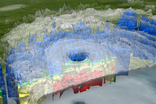
Track the hurricane from its birth in the open ocean through its catastrophic encounter with the Gulf Coast.
Credits
Images
- (Katrina over Bahamas)
- Courtesy Jeff Schmaltz at NASA GSFC
- (strike path)
- Courtesy NOAA/National Weather Service
- (Katrina track)
- Courtesy University of Wisconsin-Madison's Cooperative Institute for Meteorological Satellite Studies/NOAA's Advanced Satellite Products Branch
- (Katrina August 28)
- Courtesy NASA/Jeff Schmaltz, MODIS Land Rapid Response Team
- (rainfall)
- Courtesy NASA/JAXA
- (2005 hurricane montage)
- Courtesy Space Science and Engineering Center, UW-Madison, with McIDAS, using NOAA satellite data and a NASA Big Blue Marble basemap
Animations
- (hurricane birth)
- © NOVA/WGBH Educational Foundation
- (heat engine)
- Courtesy Susan Twardy/NASA Goddard Space Flight Center
- (Katrina path)
- Courtesy NASA/Goddard Space Flight Center Scientific Visualization Studio
- (Gulf Coast time lapse)
- Courtesy Jeff Schmaltz/MODIS Land Rapid Response Team, NASA GSFC
Related Links
-
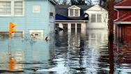
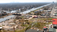
Storm That Drowned a City
Experts and eyewitnesses reconstruct the devastating floods that Hurricane Katrina unleashed on New Orleans.
-
The Man Who Predicted Katrina
Hurricane expert Ivor van Heerden warned for years that a tragedy like the one brought by Katrina was bound to happen.
-
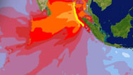
Anatomy of a Tsunami
See how the tsunami of 2004 developed, from its birth at the seafloor to its impact on coasts around the Indian Ocean.
You need the Flash Player plug-in to view this content.