3D models help preserve landmarks like Notre Dame
Laser-scanning technology can create exceptionally detailed 3D models of cultural sites, bringing them to life online—and helping experts restore them if disaster strikes.

Notre Dame Cathedral on fire in April 2019. Image credit: Wandrille de Préville, Wikimedia Commons
At the Neolithic village of Skara Brae off the northern coast of Scotland, serpentine green slopes overlay the remains of a community so complete that many of the houses feature stone beds, dressers, and cupboards—even though the village is older than both Stonehenge and the pyramids of Giza. The site, which was once home to some 50 people, overlooks the blustery Bay of Skaill. Over the millennia, wind and water have slowly eaten into the hills around the ruins, putting them at risk of eventual destruction.
Related

Saving Notre Dame

Saving Notre Dame's Stained Glass Masterpieces

Stabilizing Notre Dame's Famous Buttresses
For the last decade, the preservation organization Historic Environment Scotland (HES) has been visiting Skara Brae deveoping strategies to protect what’s sometimes known as the “Scottish Pompeii” from encroaching erosion. One of their most successful efforts has nothing to do with wood or stone and everything to do with light. Every two years, HES conservators bring laser scanners to the remote northern island to gather a 3D image of Skara Brae, including both its structures and the surrounding dunes and cliffs. Comparing the resulting data set to its predecessors has helped them identify to the millimeter how the landscape has changed.
“To be able to monitor what’s going on is essential,” says Sophia Mirashrafi, who helps coordinate HES’s digital projects and get them ready for presentation to the public. “Scanning doesn’t stop the water from eroding the site, but it can be used to help inform decisions about how it can be protected.” She and her team also used the scans—known as point-cloud models—to create interactive virtual experiences that give the public up-close access to parts of the village.
When we think about preserving cultural heritage, Mirashrafi says, we usually think about the physical: propping up carved stone, reconstructing rotted wood, uncovering precious metal. But, just as it’s being used at Skara Brae, laser scanning (also known as LIDAR) has become an essential tool at cultural sites around the world, from Notre Dame to Rapa Nui, in augmenting physical preservation, helping conservators make better decisions, and enriching experiences of the sites for both scientists and the public.
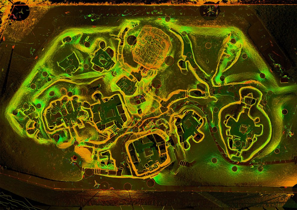
Historic Environment Scotland has used drones equipped with LIDAR scanners and photogrammetry to create aerial 3D models of the Skara Brae Neolithic site, which is older than Stonehenge. Image courtesy of Historic Environment Scotland
At the most basic level, a point-cloud model is a collection of 3D coordinates that conservators, art historians, and researchers can use to “sample reality,” says architect and computer scientist Livio De Luca, who heads the vast team of scientists racing to preserve Notre Dame Cathedral in Paris after the catastrophic fire that destroyed its roof in April 2019. Laser sensors mounted on rotating heads collect data on more than 100 three-dimensional points per second over a 180-degrees axis by measuring the amount of time it takes for light to leave the sensor, bounce off a given spot on a structure or object, and return.
Users move scanners of different resolutions (some for capturing fine details, other for larger landscapes) gradually around the site to produce a digital cloud of points. Each data set overlaps with the last, allowing them to combine those data sets in an algorithmic process called registration, and create a 360-degree “picture” of that site—kind of like doing a 3D jigsaw puzzle. Even though the lasers collect so much data so quickly, the process is still slow and painstaking. It took a team more than two weeks to scan Notre Dame, De Luca says, using some 400 scanning stations to capture as many data points as possible.
After the initial puzzle is done, the next step is to turn the cloud of points into a “watertight mesh” using a computer program—converting them from a dense constellation to an interconnected surface. Conservators often combine this mesh with data from another digital data-gathering technique called photogrammetry, which can harvest information about a structure’s texture, color, and general shape from overlapping photos of that structure.
LIDAR (which stands for Light Detection and Ranging) “gives you quantifiable accuracy,” says architect and computer engineer John Ristevski, CEO of the digital heritage nonprofit CyArk, whose mission revolves around scanning sites of historical and cultural interest around the world. “In contrast, photogrammetry provides great textures and beautiful geometry, but it’s not completely reliable. We want both.”
As the technology has improved, point-cloud models have come to play an essential role when heritage sites are damaged. Ristevski’s colleagues at CyArk finished scanning one of Bagan, Myanmar’s huge stone temples just three months before a 7.1 magnitude earthquake hit the city in 2016. Using their scans, CyArk was able to create detailed assessments of the damage and help with plans for restoration. Similarly, a Vassar professor, a 3D tourism company, and the company that makes the video game Assassin’s Creed had all scanned Notre Dame Cathedral before its fire. “The point cloud represents the main source to rebuild something, using geometrical information in a precise and accurate way,” De Luca says. “If by other kinds of restoration we were able to approximate shapes in the past, now we’re able to reproduce shapes millimeter by millimeter.”
Point-cloud modeling can also help conservators do experiments that would be impossible in real life. At Notre Dame, a new phase of reconstruction began this month to rebuild the stone ribs that once held up arches in the ceiling. Before this effort begins in earnest, members of the cathedral team will scan each individual stone, a process that will allow them to rebuild the ribs virtually—ensuring they do not compromise the rest of the structure before they are rebuilt in real life. “We’re able to more safely and, from a scientific point of view, more accurately test how they will behave in rebuilding,” De Luca says.
For HES, point-cloud modeling has not just been essential in erosion monitoring; it has also become an important teaching tool. Using LIDAR scanners and drones capable of photogrammetry, the organization has been able to scan the tops of walls (known as “wall heads”), allowing conservators a much more complete view of the structure than ever possible before. “Scaffolding is very expensive, and it’s difficult to get people up there,” says Mirashrafi. Having access to point-cloud models of the upper parts of the buildings has allowed conservators and stone masons working on the many sites HES cares for to get up close to ceilings they couldn’t access otherwise and to better monitor the health of those wall heads—even using their virtual counterparts as teaching tools for masons-in-training.
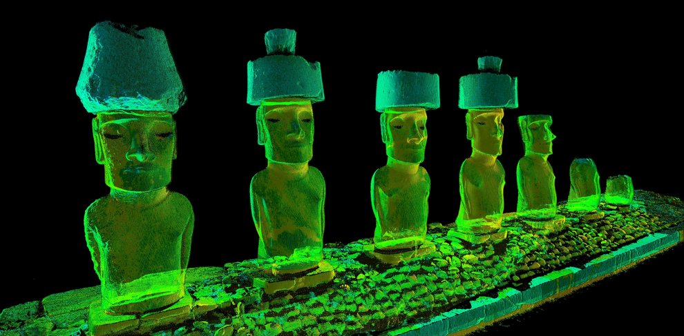
Staffers from the digital heritage nonprofit CyArk traveled to Rapa Nui (Easter Island) in early 2020. There, they taught workshops in point-cloud modeling, which will allow local resource managers and Indigenous groups to monitor the erosion of the island’s 500 moai, or enormous, ancient stone statues. Image Credit: CyArk
CyArk was founded by Iraqi-American Ben Kacyra as a way to fight the kind of cultural destruction that was typical of the Taliban and ISIS in Iraq and Afghanistan over the last decades. But as modeling technology has become cheaper and more portable, the company’s mission has changed as well, Ristevski says, with less emphasis on secure data storage and individual projects and more on open access and education.
Since its founding, for example, CyArk has stored copies of each site it scans in a secure facility 200 feet underground—the same facility that, according to urban legend, stores Elvis Presley’s master tapes. “We still do that, but it’s a less interesting piece of our work,” Ristevski says. Two years ago, CyArk also began putting its data sets online under a Creative Commons license. “Things that are burrowed away somewhere is one avenue, but now it’s more about sharing and opening up data,” he says.
Similarly, where CyArk once sought to digitize 500 cultural heritage sites under their own steam, Ristevski says what now excites him is the educational workshops the organization runs around the world. “We’ve seen a lot more adoption of this, especially in the last three or four years,” he says. In early 2020, for example, Ristevski and other CyArk staffers traveled to the South Pacific to give a workshop for monument staff and local Indigenous communities at Rapa Nui, also known as Easter Island. That site, much like Skara Brae, faces continual damage from wind and waves, so CyArk did a set of initial point-cloud models to act as a baseline, allowing for annual monitoring of how each of the island’s enormous stone statues is weathering. Helping local authorities monitor their own site makes it possible to scan all 500 sites on the island, he says, whereas CyArk might only have had time or resources for one or two.
A technique like point-cloud modeling can also create an opportunity for sorting through and storing many types of information. Notre Dame is a perfect example. “Even if today we are building a lot of data around this physical aspect, we are also building a ‘knowledge cathedral’ at the same time,” De Luca says. For his team, that means building a “digital twin” of the cathedral, a real-time virtual clone of the physical object that records more than just the geometric dimensions of the cathedral before and after the fire. This digital twin also manages the myriad chemistry, physics, art history, archaeology, and engineering data generated by its many restoration projects—from managing the flying buttresses to cataloguing each of the thousands of pieces of tangled, burnt wood that once made up the “forest” in the cathedral’s attic—and makes it available within a few minutes of its collection.
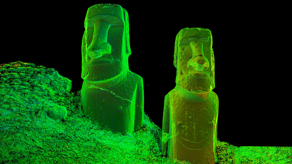
Point-cloud images of huge stone statues at Rapa Nui, also known as Easter Island. Image Credit: CyArk
Past Skara Brae, even farther north into the cold reaches of the Atlantic ocean, sits Mousa Broch, a 40-foot-tall Iron Age stone tower built around 300 BCE on a bluff overlooking the sea. Even for the few visitors that make it to the Shetland Islands, Mousa Broch is difficult to access, requiring a strenuous hike. But point-cloud modeling has allowed Mirashrafi’s team not just to gather essential records of the building for posterity but also to open the site (or a version of it) to the public.
As part of their scanning efforts, they’ve translated the point-cloud version of Mousa Broch into a version most computers can handle, through a site called SketchFab (which Mirashrafi calls the “YouTube of 3D models.”) “Sharing for education and interpretation is something we’re equally interested in,” she says. Flocks of storm petrels roost at Mousa Broch at night, so as an extra immersive touch, the team layered recordings of the seabirds over the model animation. The result: a rich virtual experience that was previously largely inaccessible.
In this vein, Mirashrafi says she’s been especially impressed with point-cloud modeling’s potential for storytelling. Being able to digitally recreate a structure or item with such accuracy helps her team fight archaeology’s tendency to strip items of their cultural context. Though the digital can never replace the physical—“When you go out and scan a site, it doesn’t negate the necessity for historians and conservators”—a digital replica is a powerful tool, she says, whether it’s used to help recreate a site before a rock fall or to help the public experience a little bit of new history.
Through point-cloud models, a lost or destroyed site can be reconstructed; an artifact can be put back virtually where it was originally found. “So often in museum contexts, it’s hand’s off, don’t touch, don’t talk, don’t question,” she says. “These kinds of virtual environments encourage manipulation and questioning,” in a richer way than you might see behind glass.
 Alissa GreenbergPosts By This Contributor